Article by Mahshad Alimardani Heravi, Benoy
Landscape architecture has always been an integrated discipline, a combination of ecological practice, design and engineering. Yet for much of the profession’s history, the tools used to communicate and coordinate landscape work have lagged behind those of different disciplines. Building Information Modelling (BIM) offers an opportunity to close that gap, not by importing architectural and engineering methods unchanged, but by adapting them to meet the specific requirements of designed landscapes.
Rethinking what the model is for
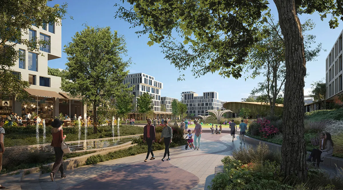
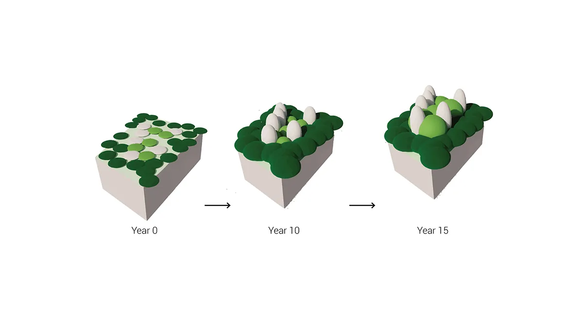
Landscape unfolds in time more gradually than buildings. A park on completion day will look and behave very differently fifteen years later because planting establishes, matures, fails and regenerates. Canopy cover reshapes shade, comfort and microclimate, while soil changes with management.
If our model only captures a single snapshot – the handover moment – it misses much of what landscape architects are actually designing. The more compelling question is how information modelling can help us shape the trajectory, not just the opening day. So rather than asking what the project looks like, we should be asking what it looks like over time.
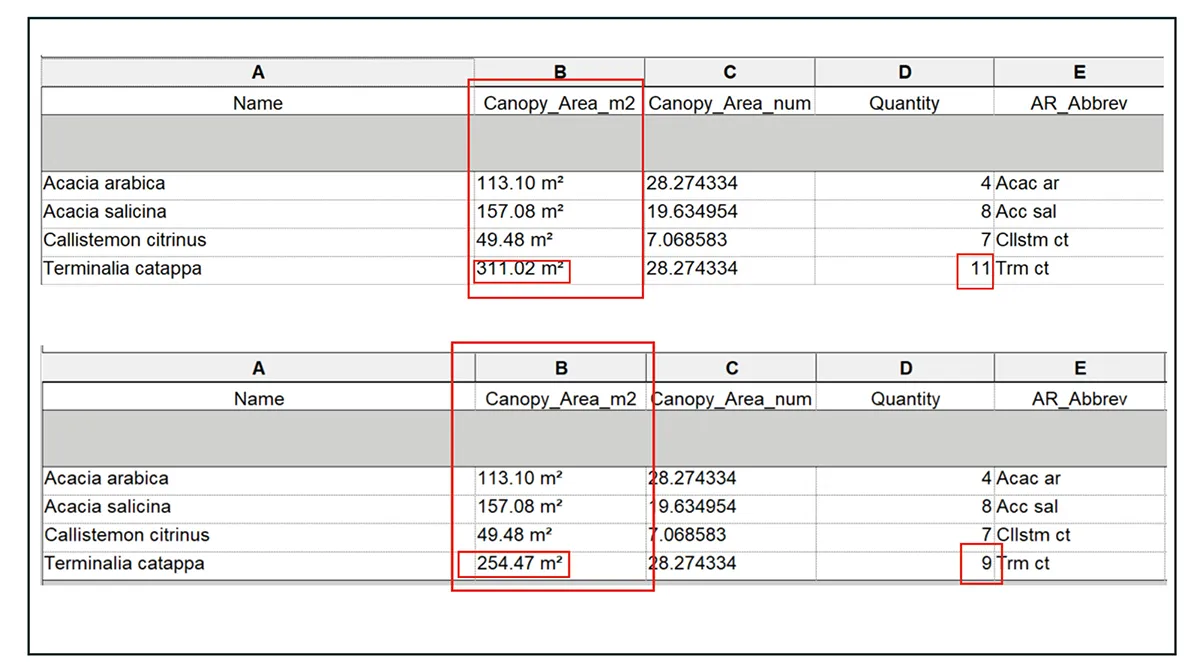
One of the most important shifts we need to make as landscape architects is moving from 3D modelling to 3D data modelling. That distinction matters more than it might sound. When our models carry real environmental data such as water demand, air quality, surface performance and planting parameters, they stop being representations and start being something we can actually trust.
This is not just useful at the end of a project. Even at the concept stage, we can attach numbers to our ideas. That changes everything about how we present them. Instead of beautiful images that everyone falls in love with and then forgets once the reality of time and budget sets in, we can offer something more honest, such as ideas that are not only compelling to look at but reliable in what they promise, based on numbers that can be explained, defended and revisited.
BIM in landscape design is not simply a delivery tool or a coordination requirement, but a way of working in which the results we extract from the model can be used and trusted across every project stage.
Information modelling raises design quality
A coordinated model introduces rigour, which improves outcomes across the board. When levels, drainage falls, planting depths, tree pits and service corridors sit in a single shared environment, organisation happens earlier and with far greater precision, meaning that landscape teams don’t discover too late that a planting bed has been compromised by, for example, a relocated duct. The core intent-generous plazas, continuous green corridors and accessible routes survive because they’re tested against reality during design, not after.
It also changes how value is discussed. When hardscape areas, soil volumes, plant counts, and irrigation demands are derived from the model rather than assumptions, budget decisions become transparent and traceable. An example of this is cutting trees, which has a measurable impact on the canopy and shade.
Environmental performance becomes something we can actively design when it is measurable. Linking plant species to data on carbon uptake, water demand, and heat mitigation lets teams compare options by outcomes rather than appearance, which in turn makes the trade-offs between strategies clearer, both visually and in terms of the environmental work the landscape will do over time.
Designing for what happens after handover
One of the most persistent failures in landscape design is the gap between design ambition and long-term reality. A year-one scene is not a year-ten scene. Maintenance regimes do not match what the planting actually needs. A well-structured model can carry information that prevents these failures, for example, maintenance schedules linked to plant species, irrigation demands mapped to growth, and material performance data that informs both specification and future management. When the model becomes a handover document rather than just a design deliverable, the landscape is more likely to perform as intended, not just on opening day, but a decade later. It helps us to show that what we are designing is not a final render, but a living system. It allows us to test whether key spaces will function well at year one, year five and year fifteen.
The deeper argument
Landscape architecture is being asked to carry more responsibility than ever, from climate adaptation to biodiversity recovery, public health to social cohesion. Meeting those expectations requires not just creative ambition but evidence, coordination and the ability to demonstrate outcomes. Information modelling is one of the most practical tools available for doing that accurately.
Ultimately, it raises quality because it gives us something designers always need more of, namely, confidence to know that the place we imagine is the place that will be built.
Article by Mahshad Alimardani Heravi, Benoy