While most 21st-century riverfront redevelopments are driven by the demands of urbanization, Touch the Water Promenade is distinct: it seeks to regenerate the ecology of the North Saskatchewan River Valley, while providing new opportunities to experience the water’s edge and accommodating critical infrastructural functions. In a unique context within Canada’s northernmost major city, the plan strikes a balance between the needs of wildlife and those of Edmontonians who cherish the river, whose daily use of the space has increased dramatically since the onset of COVID-19.
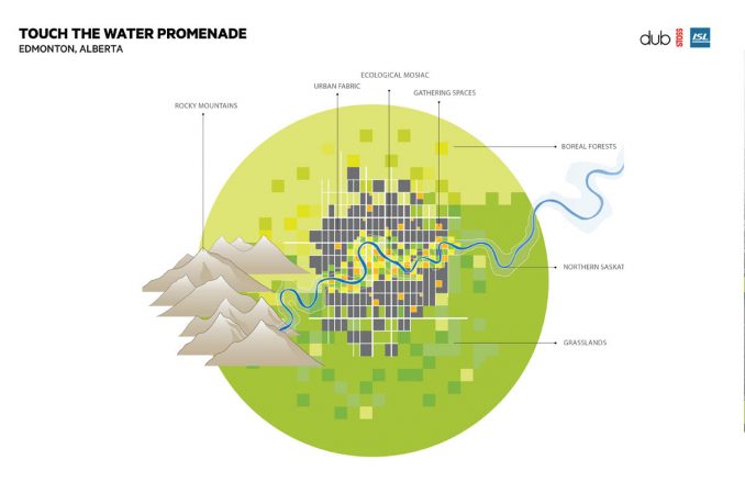

A wilderness in the heart of the city, the riverfront is essential ecologically but also culturally and socially, representing an urban identity specific to Edmonton–as an Indigenous space, where gathering, hunting, fishing, and trading has occurred since time immemorial, and a former industrial space whose degradation is finally being addressed. The project responds to this layered history by preserving and enhancing existing character while inviting people to literally “touch the water.”
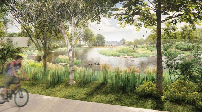
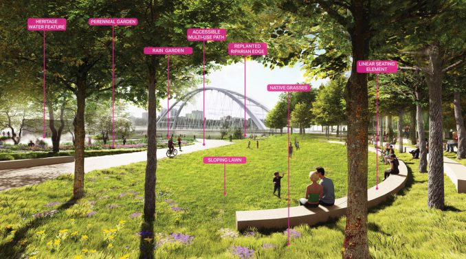
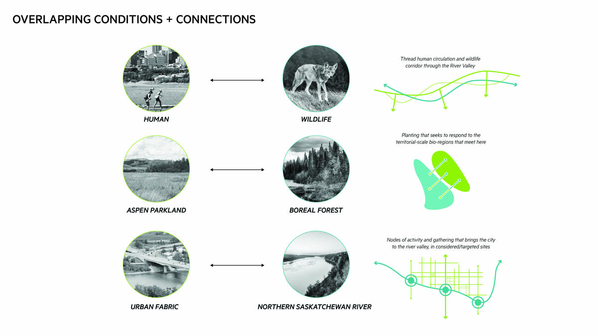
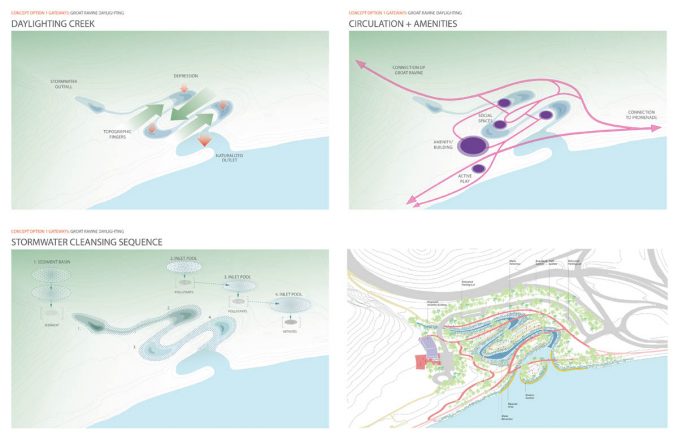
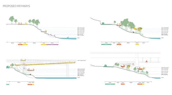
Social and ecological goals are intertwined in every aspect of the plan. The team examined questions of access–which emerged as a priority through public engagement–from multiple angles. The resulting design solution reconnects the urban fabric to the river through a series of gateways at key nodes; navigates technical constraints including steep grade changes, variable water levels, and frequent icy conditions to provide access right at the water’s edge; and sloped pathways to accommodate visitors of varied mobilities. To bring more people into the space in a manner that is compatible with its role as a wildlife corridor, the circulation design takes into account not only multimodal human movement but also avian, terrestrial, and aquatic species–by selecting plants as habitat and food sources, providing unbroken corridors for movement, and improving feeding or spawning conditions for fish using planting, erosion control, and softened riparian edges.
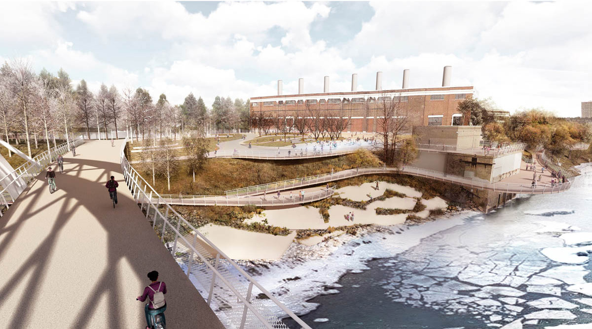
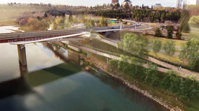
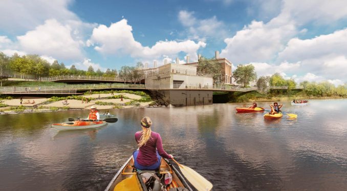
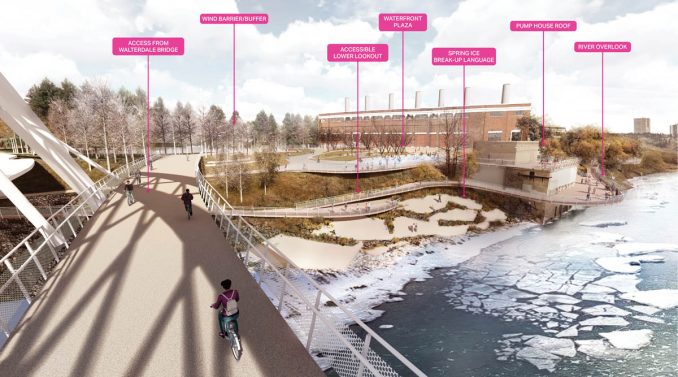
There are a number of challenging existing structures that are thoughtfully engaged, enhancing access and connections while paying homage to the site’s deep and layered history. A central component to the project is a large gathering space positioned at the top of the riverbank consisting of lawn, plaza and deck, enveloped in forested topography. This vital community amenity sits alongside the historic Rossdale Generating Station, which is proposed to be repurposed as a dynamic cultural facility that brings visitors to the area during all seasons. This industrial relic provides a striking backdrop and companion to a space that is designed to facilitate use and activation at a variety of scales and throughout the year.
Edmonton is a winter city, with temperatures and weather conditions fluctuating drastically throughout the seasons. The plan embraces this fact, as it is a central component of the identity of the city and its people. Connections to the surrounding city fabric are made regularly to provide multiple points of access and are designed to be accessible for all users and in all weather conditions. The architectural form of a waters-edge access reflects the forms of the “frazzle pan” ice flows that glide down the river during winter. Careful consideration of the orientation and elevation of structures in or near the water is required to respond the damaging ice flows that occur each spring. Plantings are utilized to buffer spaces from prevailing winds and to provide colour and dynamic qualities to a white winter landscape. A subdued lighting strategy creates spaces that feel safe for users during the long winter nights while respecting the ecological functions of the area as wildlife habitat and corridor.
Environmental Leadership
The Touch the Water Promenade plan is rooted in ecological sensitivity, creating new spaces for Edmontonians to cherish while rehabilitating damaged or denuded areas of the river valley. Ecological objectives are prioritized alongside the need to create vital and accessible spaces that are embedded in the landscape of the valley.
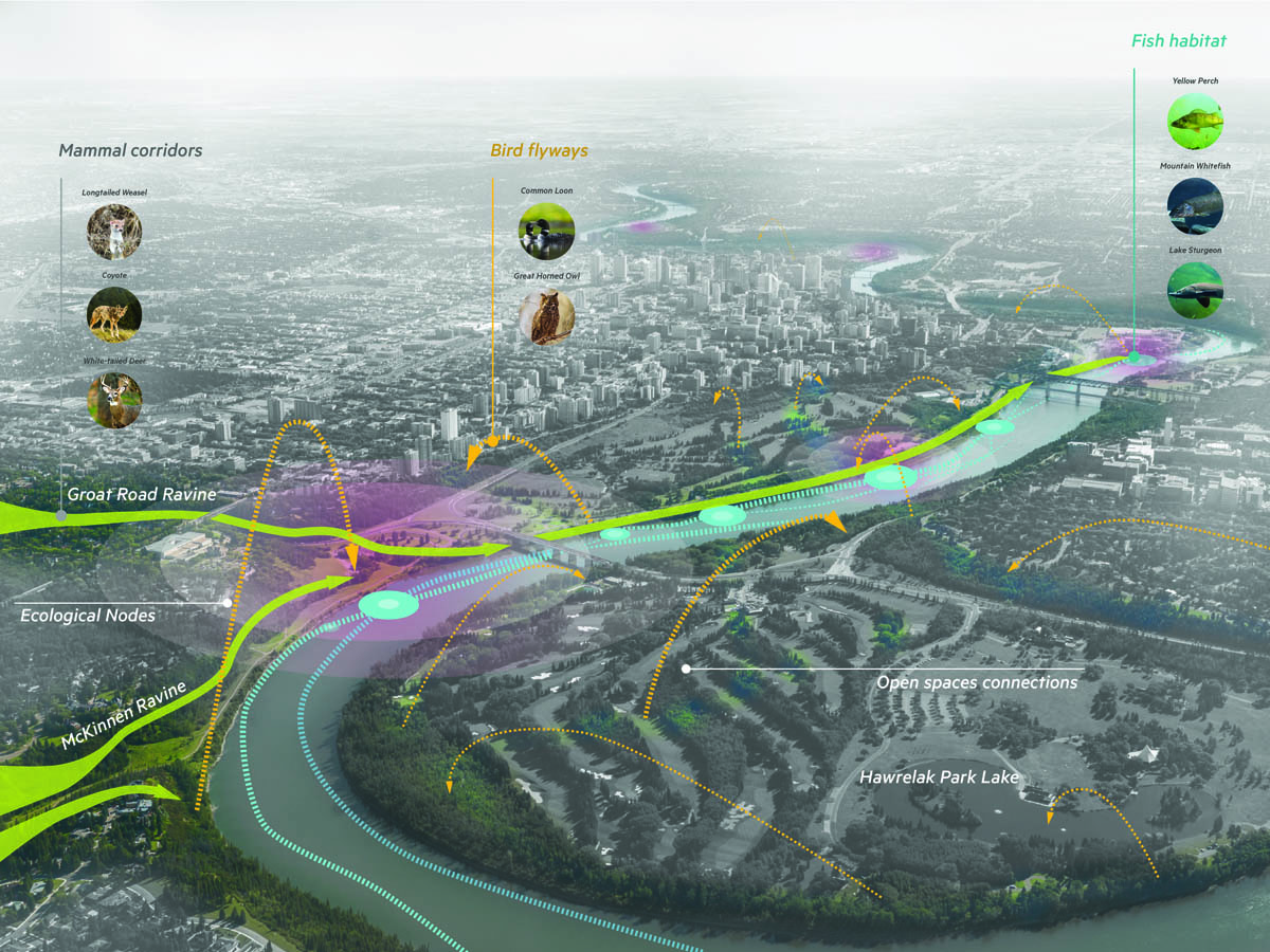
Key aspects of the ecological fabric include the daylighting of a historic drainage way in Groat Ravine that was converted into an underground pipe and outfall decades ago. This daylighting effort utilizes natural materials and processes to detain and cleanse the stormwater from upstream neighbourhoods prior to discharging to the river. New habitat is created and opportunities for educational and interpretive materials to be utilized on the site.
The riverbank within the plan area is a critical wildlife corridor for a variety of species. Careful attention is paid to the location and elevation of structures on the riverbank to minimize disturbance to habitat and paths of movement. The majority of structures are elevated above the forest floor, providing unimpeded space for wildlife movement below.
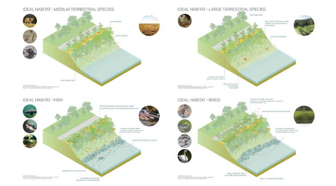
While the forested slopes of the river appear to be perfectly native environments, there are actually significant patches of invasive and non-native vegetation present. Where forested areas are disturbed by the creation of new infrastructure, purely native vegetation will be utilized in re-establishing the vegetative cover. The use of pioneer species in the initial planting will allow for the natural transition of the forest species make-up over time. Denuded areas will be planted to establish forest cover that also serves to stabilize the soils on the riverbank, reducing the potential for erosion of the bank and the deposition of materials into the river.
While the plan does not get into the details of specific materials and construction systems, it is intended that materials with low embodied energy will be prioritized, as well as materials that are locally sourced to minimize the environmental impacts of shipping and transport. Local fabricators and manufacturers will be sought to provide furnishings and custom elements, rather than selecting catalog products that would be manufactured and shipped from outside of the region.
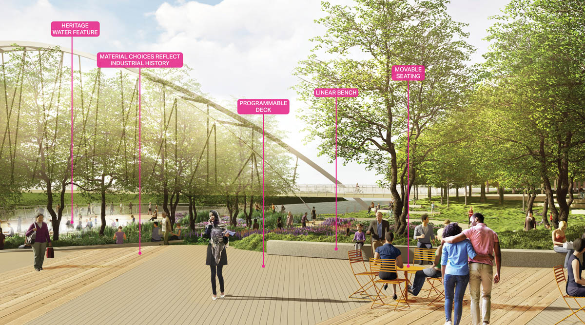
Lastly, and perhaps most importantly, the plan provides infrastructure that allows people to move through the area by walking or wheeling, minimizing reliance on automobiles. The broad promenade provides separate spaces for people moving slowly, strolling on foot, and for people moving rapidly, by bike or other wheeled equipment. Spaces for rest are provided regularly, encouraging users of all abilities to use the promenade. The length of the promenade is well lit, facilitating use in the evenings and during all seasons.
Touch the Water Promenade
Location: Edmonton, Alberta, Canada
Client: City of Edmonton
Landscape Architect: Stoss Landscape Urbanism – Chris Reed, Daví Parente Schoen, Amy Whitesides, Mateo Yang, Albert Chen, Han Yu, Kanani D’Angelo;
Landscape Architect of Record: ISL Engineering – Kevin Dieterman;
Architect: Dub Architects – Michael Dub, Cass Milford, Walter Di Tommaso, Graeme Haunholter;
Image Credits: Stoss Landscape Urbanism