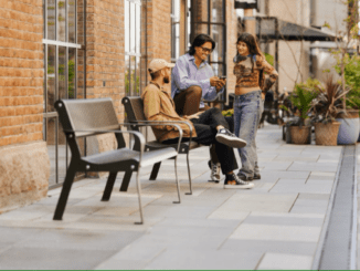
The advances in technology are impacting landscape architecture design processes, inventory and analysis, research and construction. These changes are improving the process and how we visit, analyse, collaborate, design and built landscape architecture projects.
Inventory and Analysis
The increase in aerial photography quality has increased dramatically in the past decade with the availability of high-resolution images and the ability to use tools such as street view for undertaking a precursory walk around sites. Also, access to historical photographs allows us to understand the changes in and around the area.
Apps for site inventory and intercept surveys provide us with tools and templates to record consistent data easily shared with teams, clients and consultants. The use of apps (social media) and tablets has greatly increased the efficiency of site surveying and undertaking community surveys. There are also software and apps for plant identification, climate analysis (wind, sun, shade), planning information, and property information(size, value, etc.). These apps provide us with information that previously had high costs and lead times to get the information, whereas now it’s readily available on the internet.
The ability to take 3d scans (or photographs) and convert them to a 3D model using point cloud services provides designers with the ability to walk around sites and review sites in 3d. This is a valuable tool compared with sorting through hundreds of site photos to interpret and evaluate the site as often items can be missed or out of the cameras field of view.
Drones and car-mounted cameras allow landscape architects to undertake inventory and views at aerial and eye-level (dependent on local laws). The captured video footage allows designers to review and walk around sites to go back and check the site without the need for additional visits. Drone with sensors and accessories such as LiDAR adds another level of detail and complexity that can assist with terrain modelling, tree inventories, assets identification for utilities and much more. These tools are not only valuable for landscape design but also landscape impact assessments.

Point cloud of a street intersection using a lidar mounted on a car
Credit: Daniel L. Lu (Wikicommons)

Credit: Waikinl (Wikicommons)
Public accessible data is also changing the way we take inventories and analyse sites. Many cities provide access to open-source data such as pedestrian foot traffic, cyclist numbers, vehicle traffic and much more allowing designers to review and understand what is happening on or near a site in a 24 hour period. In contrast, previously, we were limited to the data we gathered during a site visit.
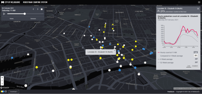
Image Credit: (c) City of Melbourne
Social media is also allowing us to see how people interact with a place through hashtags, location tagging and general interactions within and around the site.
Collaboration and Concept Designs
There are many tools available for collaboration from video conferencing, mind mapping, sketching, group editing, file sharing and much more. These tools make collaborating with teams in our offices, cities and far away places much more effortless. Gone are the days of CD’s and USB drives being sent by courier.
The ability to collaborate and share information between teams and consultants has made it easier to develop ideas and concepts for sites in real-time. The ability to draw together precedents and imagery and sketch out ideas together allows us to design in a visual medium that is inherent to how designers think and interact.
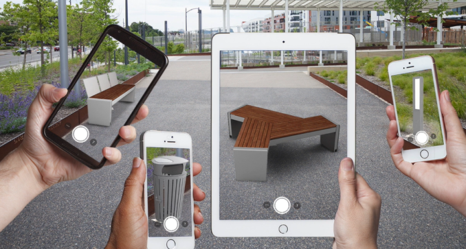
Furniture suppliers, lighting companies are supplying design tools include augmented reality apps that allow designers to place an object(seat, bollard, light) in the space.
Design Development
3d modelling (whether in Sketchup, CAD, Vectorworks) allows landscape architect to develop designs and test alternatives during the design development. Some software can provide alternative solutions for paths, grading, walls based on parameters provided.
The use of BIM has changed the way that we can collaborate within our offices and with consultants. Bringing together the architecture, engineering and landscape in one model makes it easier to test designs and resolve any clashes or issues. Although the technology may not be perfect, it allows us to develop ideas and solutions to problems before documentation or construction.
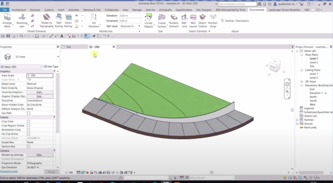
Plugins for CAD and BIM have also improved significantly as landscape architects have developed tools for their own design processes and shared them with other firms. Our recent new WLA partner Arch-Intelligence has created a plugin Environment for Revit to simplify terrain modelling processes. As more people develop tools for landscape architects, there will be greater adoption of BIM software.
Construction Documentation
Through BIM and CAD software and the ability to move away from blueprints/Black & white drawings to more developed drawings and 3d models. Construction companies’ ability to utilise a model to develop more detailed drawings and prototypes increases efficiency and reduction in waste.
Documentation has also changed with the ability to test designs in 3d modelling and 3d printing. This increases the designer, client and contractors confidence that the built design will be as intended. It also allows for testing and refinement of complex ideas.
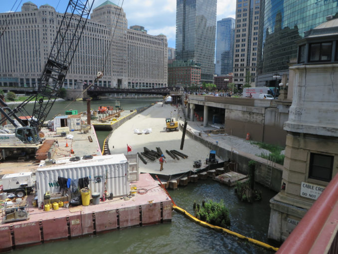
Construction
Construction has changed with the use of models and detailed documentation to reduce waste and improve the connections and interfaces between various disciplines (architecture, engineering, lighting, etc.).
We can now view sites with live streams and mobile phones, allowing the designer to see progress from afar. It also allows contractors to discuss and confirm design questions with designers through facetime or similar apps. Of course, there are still regular site visits but less of the early/late callouts to the site to work out a problem that could be easily solved with the video call.
Undertaking reports (reviews, defects, etc.) on-site is now easier with phones and tablets with apps or templates. You can take site photos, bring them into the drawings or a site report, complete it on-site and issue it for rectification. This speeds up the process and reduces the delay or possible need for further costly rectification. There are more advances on the way with Artificial Intelligence and image recognition that count plants, measure units and distances.
Technology is impacting the way we design and build landscape architecture projects. Whilst I have tried to cover many of the changes occurring, this article focuses on how technology is impacting landscape architecture processes.
There are many more ways that technology is impacting the landscape architecture, including data analysis, communications, marketing, sourcing, supplying and many other areas of the profession.
The increasing impact of technology does have its benefits and downsides, however, I think that we can all agree that technology is improving the way that we work together, design and building projects.
How technology is changing Landscape architecture processes article was written by Damian Holmes – Editor of World Landscape Architecture. To discuss this topic with the author to provide feedack via email [email protected]
DISCLAIMER: This article is for educational purposes only. The content is intended only to provide a summary and general overview on matters of interest. It’s not intended to be comprehensive, nor to constitute advice. You should always obtain legal or other professional advice, appropriate to your own circumstances, before acting or relying on any of that content. This advice is general in nature.