
Julia Wilson is a Spatial Urban Planner in the AtkinsRéalis Landscape & Masterplanning team and has worked on a range of landscape projects across the UK. WLA recently had the opportunity to discuss Julia’s thoughts on landscape architecture and city planning/design, technology, and her day-to-day work as a Spatial Planner.
WLA | What does your day-to-day work involve as a Spatial Planner in Landscape & Urban Design?
I work nationally across the UK and Ireland as part of the Landscape & Urban Design team at AtkinsRéalis, contributing to projects that range from small, housing‑led regeneration schemes, to complex large‑scale masterplanning projects. My day‑to‑day role is focused on supporting landscape and urban design projects through strong spatial analysis and producing user friend GIS mapping and digital apps to support clients and enable community engagement.
At the heart of my work is GIS (Geographical Information Systems), which I use to help the team understand the landscapes, towns and cities where our projects are located. I bring together environmental, social and physical datasets to reveal patterns, opportunities and constraints. This helps to inform our projects will involve the likes of landscape and urban design strategies, placemaking proposals and feasibility studies, ensuring that proposals are grounded in evidence and respond sensitively to their context.
A typical day could start with collating designation data for an LVIA (Landscape Visual Impact Assessment) project and then I could be moving onto a Regeneration project collating and overlaying different data types for instance, flooding and deprivation data to find water opportunity areas. This pulling together of data across different projects reveals relationships between people, landscape and infrastructure that might otherwise remain hidden, turning analysis into insights.
Community engagement is also an important part of my role. I support engagement and consultation through digital mapping and interactive platforms, helping communities and clients understand proposals spatially and ensuring local knowledge feeds back into the design process.
No two days are the same in my role. I might move from detailed GIS analysis to design workshops, from preparing visual material that sparks discussion to responding to client queries or shaping the narrative of a report. It’s this blend of analysis, design and storytelling that excites me most, using spatial data not just to inform projects, but to help create landscapes and urban environments that are people‑centred, expressive and rooted in place.
WLA | How do you see the relationship between landscape architecture and city planning/design?
I see the relationship between landscape architecture and city planning and design to be closely interdependent. Most of our projects are within urban settings, where landscape architecture plays a critical role in shaping how places function, feel and are experienced. It is essential in creating spaces that are imaginative and memorable, while balancing technical requirements with natural systems, environmental constraints and human use.
City planning and urban design provide the wider spatial and strategic framework within which landscape architecture operates. Through spatial planning and mapping, projects are situated within a broader urban context, considering movement, land use, connectivity, density and long‑term growth, ensuring that landscape‑led interventions align with local policy objectives, regeneration strategies and deliverable urban frameworks. From my role, this broader perspective is invaluable, as it enables landscape thinking to respond not just to site conditions but also to wider social and spatial patterns.
At AtkinsRéalis, we work from the outset on projects with these disciplines in mind on our urban based projects. Collaboration happens early, ensuring that neither landscape nor urban design is treated as an afterthought, but instead forms a core part of shaping proposals that support placemaking, green and blue infrastructure, climate resilience and inclusive public realm.
WLA | What role does technology play in your work?
Technology is central to my role within the team. I use Geographic Information Systems (GIS) on a daily basis for baseline analysis at project inception right through to presenting material at consultation. I work extensively with Esri’s ArcGIS Pro and ArcGIS Online, which together allow analysis, collaboration and storytelling to sit seamlessly alongside landscape and urban design.
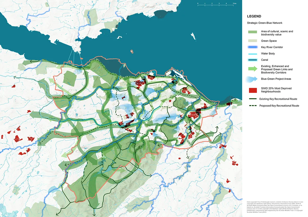
ArcGIS Online has a wide range of apps and tools for hosting mapping and information online. The team regularly use ArcGIS StoryMaps to bring together project information, visuals and narrative for local communities and wider audiences, supporting engagement and enabling feedback. StoryMaps produced range from the Shandon Integrated Urban Strategy in Cork City to the showcasing of the Green‑Blue Network for the City of Edinburgh Council, helping translate complex strategies into clear, place‑based stories.
ArcGIS Online is also a valuable collaborative platform, allowing data to be shared across our multidisciplinary teams, clients and sub‑consultants. An example of this is on our Clyde Mission Strategic Masterplan Project, which spans an 80 km stretch of the River Clyde in Scotland and involves multiple local authorities and stakeholders. ArcGIS Online has been used to bring together extensive datasets within a single, shared spatial environment. This has allowed our client and sub-consultants to explore the project baseline mapping, develop strategic themes and emerging ideas collectively.
I have also introduced ArcGIS Field Maps to the team. This is a mobile, on‑site data collection tool. This has proven particularly effective on large‑scale landscape management projects, such as motorway corridors in England, where planting and landscape assets need to be assessed systematically and accurately in real time.
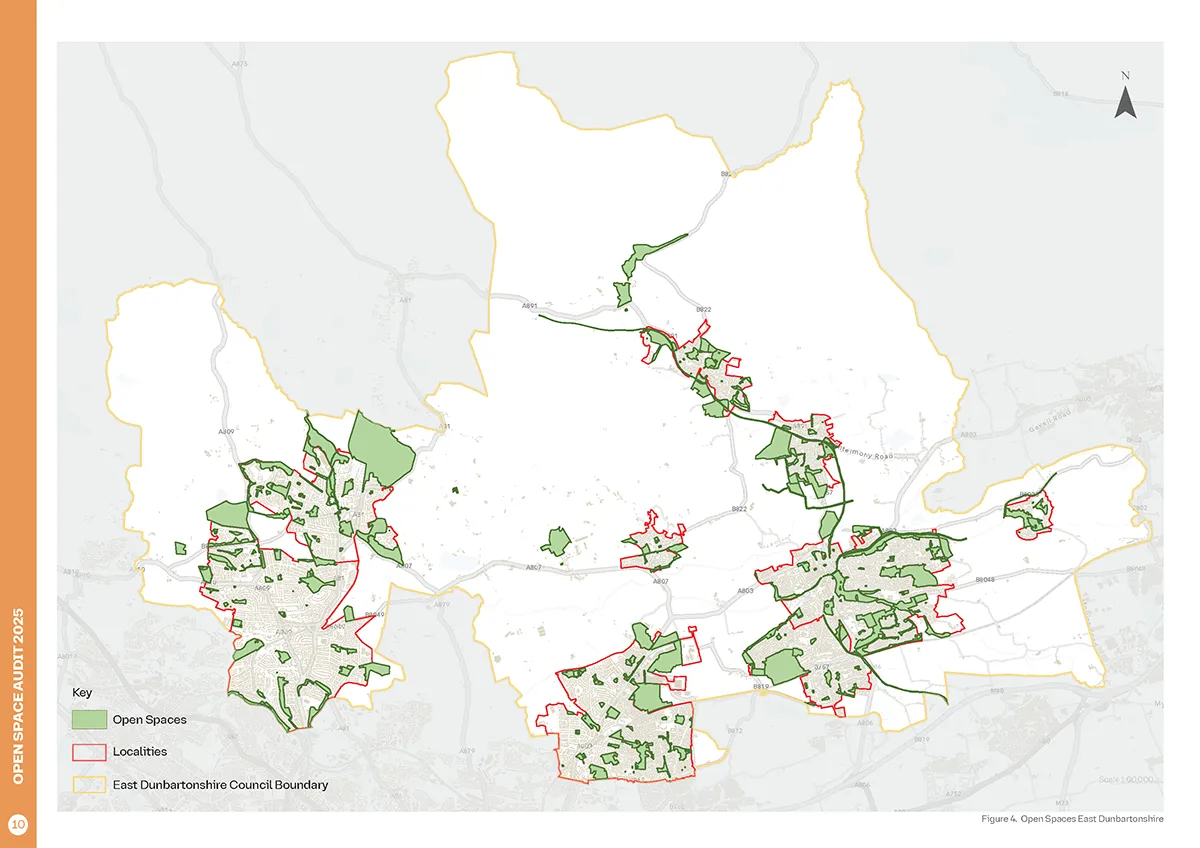
ArcGIS Pro does the heavy lifting on projects. It can handle large and complex datasets and supports advanced spatial analysis and 3D visualisation. I use it extensively for LVIA work and for strategic landscape‑scale projects such as East Dunbartonshire Council’s Open Space Audit, where over 200 open spaces were analysed and audited for their accessibility, quality and quantity.
Ultimately, GIS technology enables me to translate complex datasets into accessible maps, diagrams and interactive outputs that actively support landscape and urban design‑led analysis, design thinking, masterplanning and placemaking.
WLA | How do you use data to inform landscape architecture strategies and planning?
Data plays a central role in our projects. I collate and analyse spatial, environmental and social datasets to help build a clear understanding of place before designs or a strategic direction is developed. This ensures that landscape and urban design‑led proposals are grounded in evidence and respond to real conditions on the ground.
Using GIS, I bring together datasets such as land use, green and blue infrastructure, movement patterns, demographics, environmental constraints and policy designations. This allows me and the team to identify opportunities and constraints early on in Projects and understand how landscapes function at different scales, from individual sites to wider urban and regional contexts.
GIS also plays a key role in revealing meaningful insights. An example of this is in our Open Space Audit for East Dunbartonshire Council, where network analysis tools were used to assess walking, wheeling and cycling accessibility to the open spaces. This analysis moved beyond simple distance measures, instead showing how long it actually takes people to reach their nearest open space. By mapping accessibility in this way, we were able to highlight patterns of proximity, uncover areas of potential deficiency and identify communities experiencing reduced access, providing valuable evidence to help inform more equitable, people‑centred landscape planning and investment decisions.
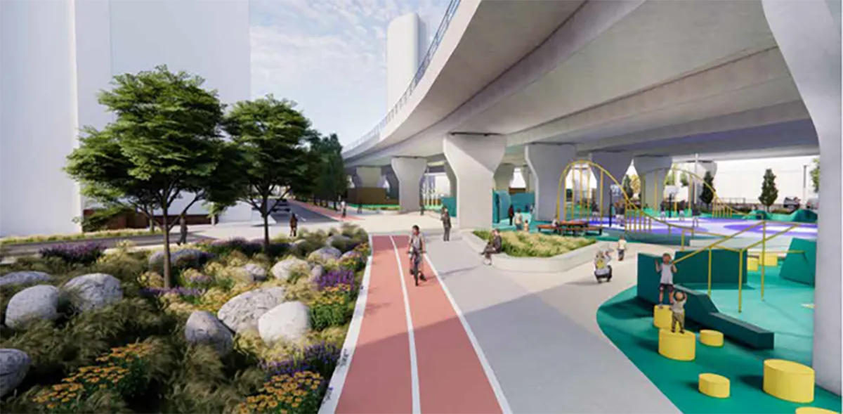
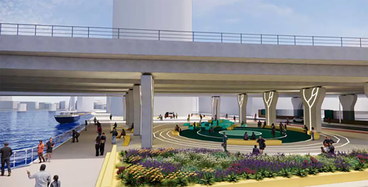
Another example of drawing design insight from mapping evidence is Under the Bridges in my home city of Belfast, a RIBA Stages 1–3 project, exploring the transformation of the space beneath the M3 Lagan Bridge into an urban sports and public realm destination. Here, GIS was used to map frontages and edges within the site boundary to help the design team and client understand the prevalence of inactive frontages and hostile facades in the area. This then helped to inform how the streetscape could be improved through landscape and urban design, creating a place-responsive intervention.
Data is essential in testing and refining options. By comparing different scenarios spatially, GIS and spatial planning support evidence‑led decision‑making, ensuring that proposals are informed, people‑focused and responsive to both environmental systems and social needs. I use data not just as a technical exercise, but as a design tool, translating analysis into clear maps, diagrams and visuals that directly support landscape architecture, urban design and planning discussions.
WLA | What key skill should every young landscape architect or planner learn?
I believe that every young landscape architect or planner should learn how to use GIS. It is one of the most accessible and user‑friendly tools in the industry, and it can also be free. Freeware applications such as QGIS and Google Earth Pro are excellent entry points, offering powerful analytical tools alongside satellite and historic imagery.
I believe maps are central to our profession; they can be simple and technical, communicating constraints, designations, or data, but they can also be complex, expressive, and exploratory, drawing together multiple strands of information to reveal patterns, relationships, and opportunities. GIS has changed the way I read landscapes and cities, allowing me to move fluidly between analysis and design, and to tell clearer, compelling stories about places for our clients and communities alike.
Thank you, Julia, for taking the time to share your thoughts and insights as a Spatial Planner in the UK.