The rebirth post extreme challenges often propels a city towards greatness. As Wuhan, the first city hit by the pandemic rethinking its resilience strategy for urban development and gradually improving the ability of vulnerable areas and people to respond to disasters in the post-epidemic era.
Thereby, South Core, the Central Zone of Wuhan Optics Valley Urban Design, has become a chance we take to help Wuhan reconsider its urban planning strategies. According to the three processes of emergence, outbreak, and subsiding that disasters and pandemics usually go through, we introduce the 3xP- Prevent, Protect, Prepare-urban design methodology, which guides urban design and enhances urban public spaces’ diversity, fairness, and adaptability. The design takes public participation and practical planning guidance to establish a safer, healthier, more resilient, and livable living space for Wuhan citizens. This design aims to pioneer adaptive city development in the post-epidemic era worldwide.
3xP Frameworks:
1. Prevent: Establish a Resilient environment
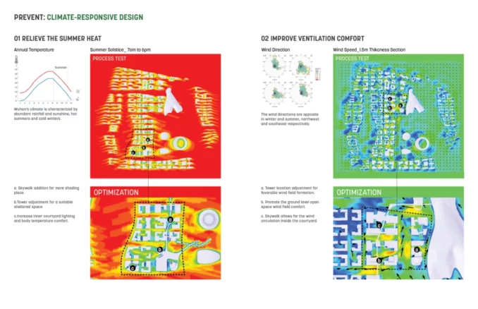
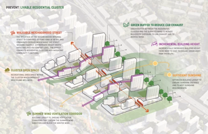
A resilient ecosystem is a guarantee for preventing all kinds of emergencies in the city. Numerous studies have demonstrated that COVID-19 transmission rates are significantly influenced by climate conditions such as wind speed, humidity, and temperature. Therefore, accelerating urban ventilation and maintaining comfortable humidity and temperature can help reduce the risk of infection. The project utilizes local climate data of wind and thermal simulations, contributing to design iterations, such as block scale reductions, building orientations, urban wall openings for the summer wind, etc. The plan aims to provide a healthy and comfortable micro-climate condition for outdoor activities.
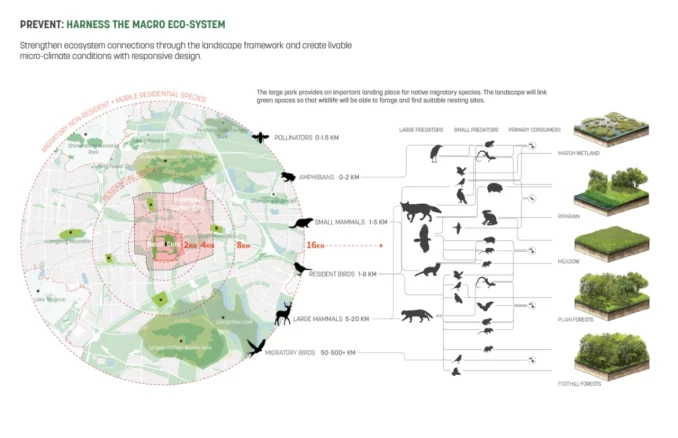
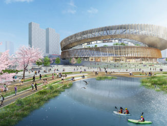
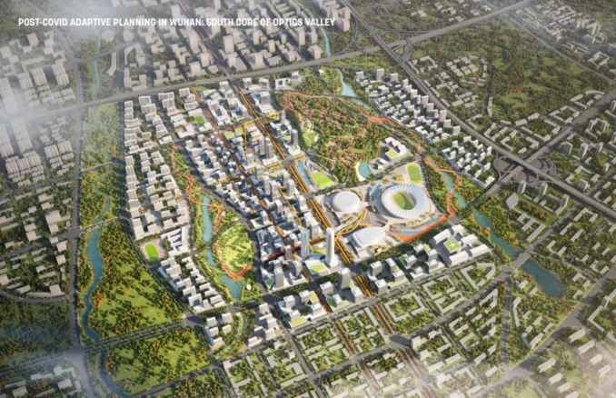
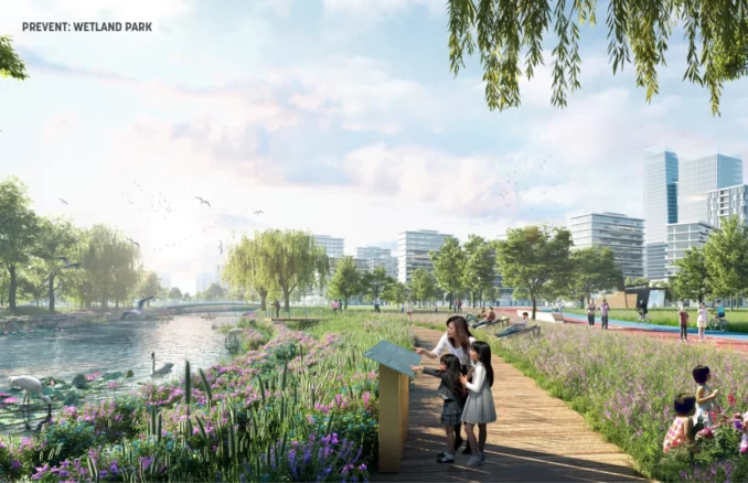
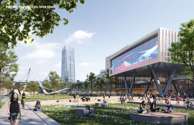
The design plan also integrates the existing site elevation with the regional ecological corridor system to establish a comprehensive and multi-level urban park system that serves as a resilient sponge city system. This approach improves regional ecological resilience and physical health while providing residents with leisure, sports, and education opportunities. The open space systems are multi-leveled, from Hill Park to the Central Plaza, street landscapes, and community green spaces, to enhance rainwater management and soil conservation capabilities. Furthermore, the green space system connects to large-scale regional green areas, creating an open and shared ecological habitat for wildlife and birds.
2. Protect: Introduce Human-scale Neighborhoods
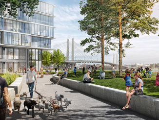
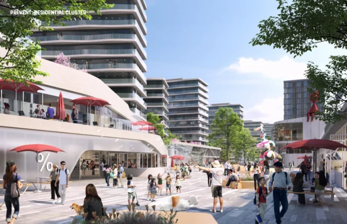
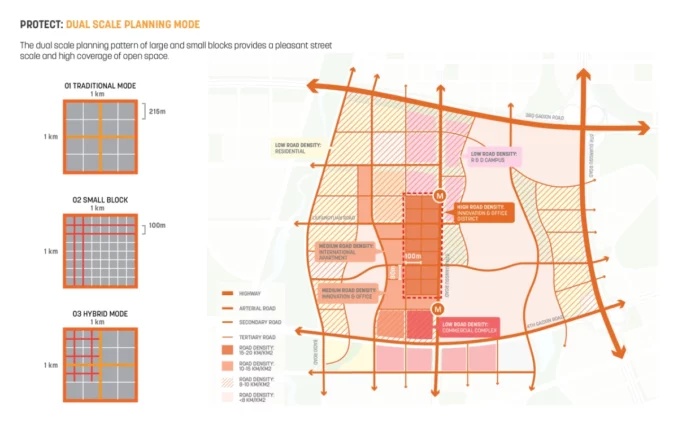
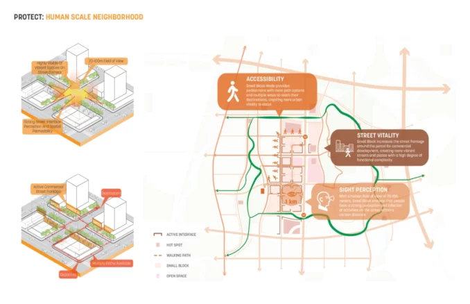
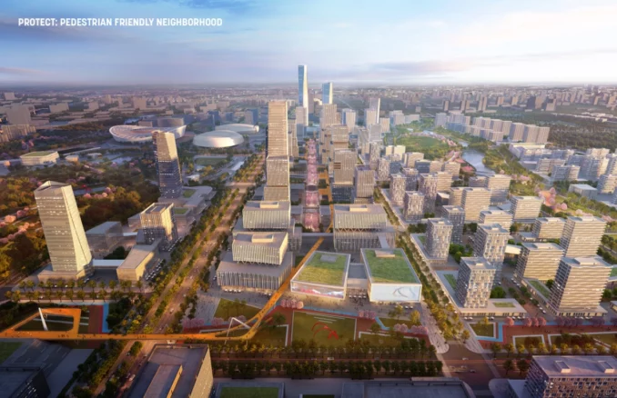
During the pandemic, autonomous neighborhood management proved effective against challenges like medical shortages and social isolation. A hybrid block system combines small grids for pedestrian-friendly alleys with larger grids for flexibility and reduced vehicle reliance, enhancing transportation efficiency. Rethinking social interaction leads to pedestrian-friendly streets and open-air spaces for events and commerce, with plazas doubling as emergency shelters.
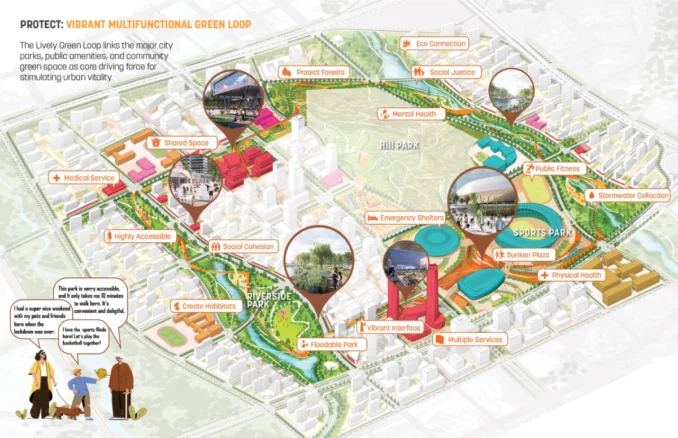
Protect strategy is built upon a comprehensive open space framework. The Vibrant Multifunctional Green Loop links the major city parks, public amenities, and community green space as one of the essential centerpieces of the project. People can conveniently access civic programs along the loop within proximity through the connected pedestrian network. Its spatial layout increases the boundary and integrates all functional blocks, fully reflecting the maximum value of public green space. Besides, the Green Loop links a series of urban plazas, forming a completed and unified urban open park system that provides more possibilities for the city’s resilience response.
3. Prepare: Intelligent Interactive City
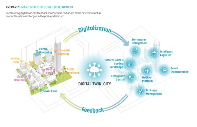
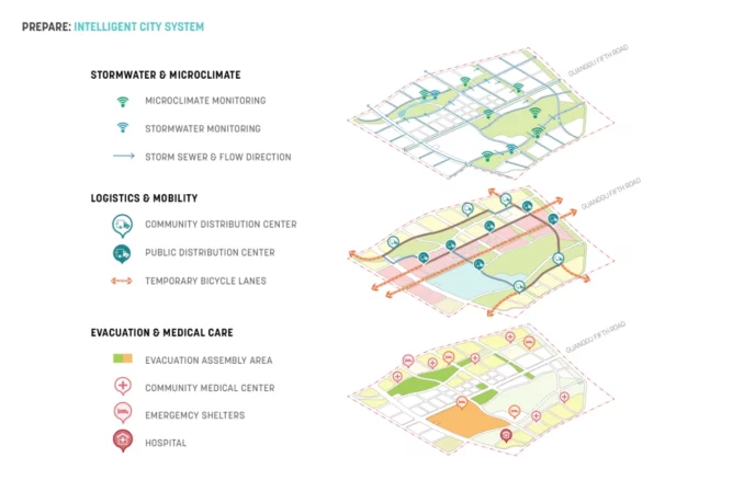
The Optics Valley master plan also aims to innovate and integrate new technologies, such as IoT, 5G, and City Cloud, to better cope with unknown challenges in the future. At the perception layer, sensors would be deployed throughout the city to collect citizens’ health status and monitor traffic and transportation, environmental and atmospheric data, as well as social activities. 5G technology is used to achieve real-time high-speed transmission of city information. The city cloud system provides comprehensive and real-time control of urban emergencies, enabling quick decision-making and responses. Smart mobility initiatives, such as temporary bicycle lanes and expanded pedestrian walkways, would boost alternate modes of transport and mobility.
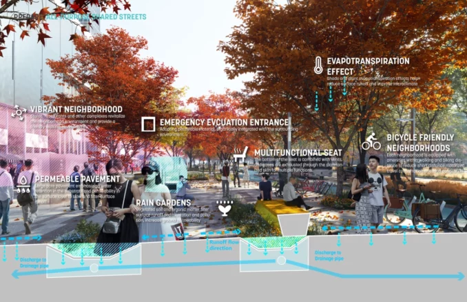
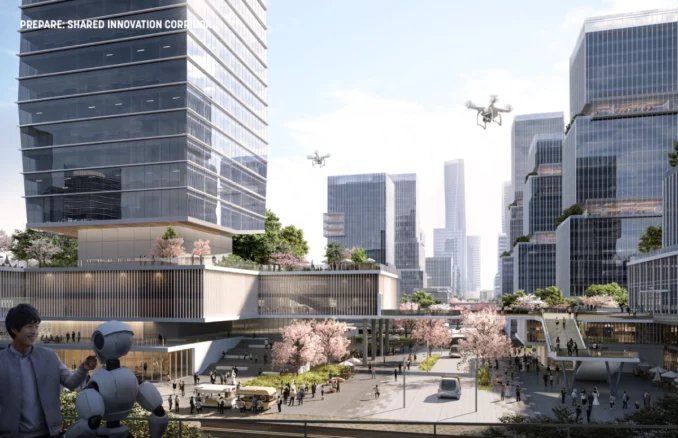
Street is another essential carrier for building an adaptive city. The design plan proposes a guideline for complete streets, emphasizing integrating street space and landscape elements. The guideline outlines four main strategies: Pedestrian priority, Vibrant neighborhoods, Ecological networks, and Intelligent systems. Good accessibility and barrier-free access guarantee a comfortable walking experience. Diverse elements, such as movable retails, humanized furniture, and functional landscape, bring much vitality to the neighborhood. Increasing the adoption of local plant species strengthens native features and improves ecological resilience.
Conclusion
In the new era of urban development, the South Core of Wuhan Optics Valley is dedicated to developing a multifunctional space that seamlessly integrates technology, culture, entertainment, and residential quality. The landscape-oriented urban design principle and 3xP strategy establish a robust ecological environment, enhance the urban micro-climate, ensure accessibility to open spaces, and create a smart city system and complete street network that facilitate timely feedback. The South Core of Optics Valley urban design project reflects on the past while providing a vision for the future, serving as a model for an ideal living space that is safe, healthy, resilient, and livable.
Post-COVID Adaptive Planning In Wuhan: South core of Optics Valley
Location: Wuhan, Hubei, P.R. China
Designer Credit: Sasaki Associates, Inc.
Client: Wuhan East Lake High-tech Development Zone Management Committee
Collaborators: Wuhan Planning & Design Institute
Image Credits: Sasaki Associates, Inc.


