Honourable Mention for the 2021 WLA Awards – Concept – Analysis & Planning category
Fantasy Island: The Galápagos Archipelago
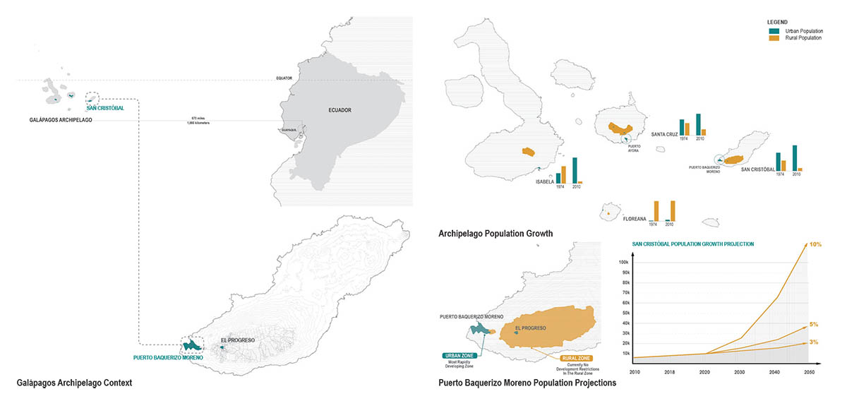
The Galápagos archipelago is one of the most important conservation sites in the world. 97% of its land is protected in the National Park and 95% of its native biodiversity is intact. However, the Galápagos is not just home to giant tortoises and blue-footed boobies – a rapidly growing population of ~34,000 people are concentrated on four of its thirteen islands.
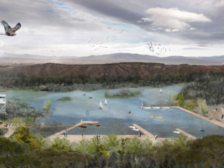
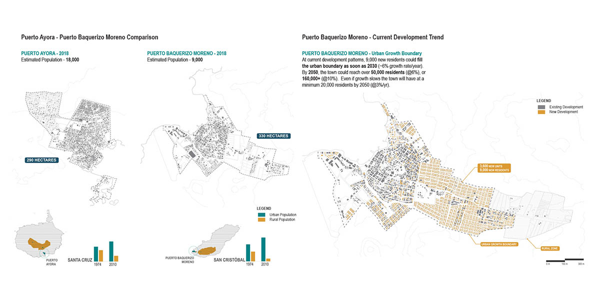
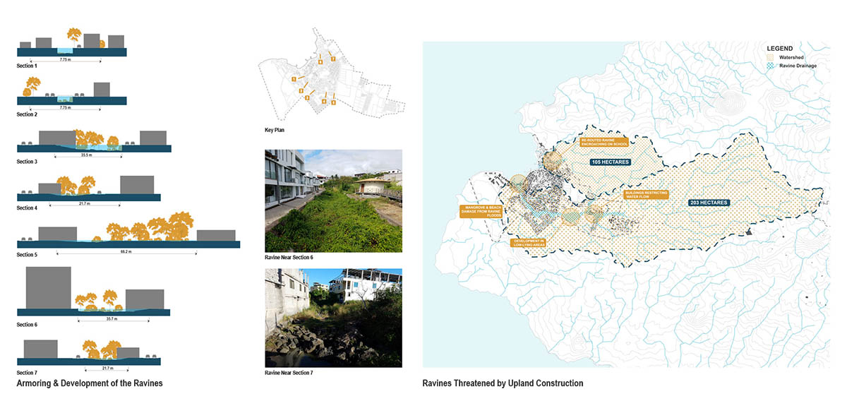
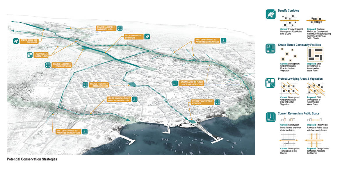
The enormous amount of attention given to the natural environment of the Galápagos has not been extended to the urban areas. There is little to no planning and residents suffer from lack of clean water and limited access to the nature for which the islands are famous. The town continues to develop upland without consideration of the topography and ravines, which are critical for rainfall flowing from the highlands. At recent growth rates of over 6%/ year, compared to 2% on the mainland, San Cristóbal’s population will double in just over 10 years, and fill its urban boundary in 15-20 years. The protection efforts in the National Park are not applied to areas within the urban boundary. Thus, the existing open areas of Puerto Baquerizo Moreno are disappearing quickly. This would both threaten the ecological resources it relies upon while locating residents in precariously low-lying, flood prone locations.
Our landscape strategy concentrated primarily on the yet to be developed areas, and emphasized four principles: 1) continuing mixed development and more density upland, which follows the pattern of the oldest areas of town, rather than a “single house on a lot” model that is now prevalent; 2) the creation of multi-use community spaces within development blocks; 3) accommodating existing water flow patterns and significant vegetation patches; 4) establishing a ravine set back and envisioning it as a new connective corridor that will bring the natural beauty of the national park into the town, thus experientially and ecologically enriching the quickly densifying town.
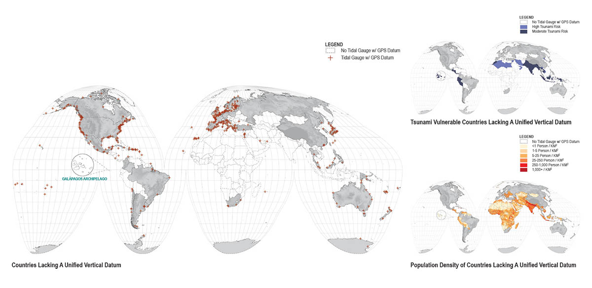
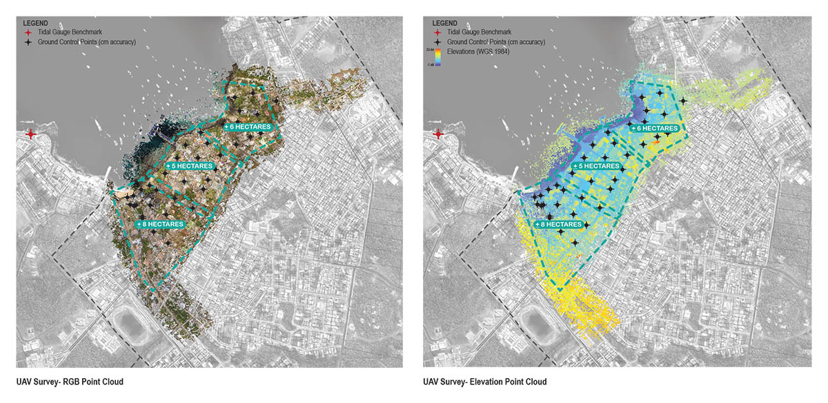
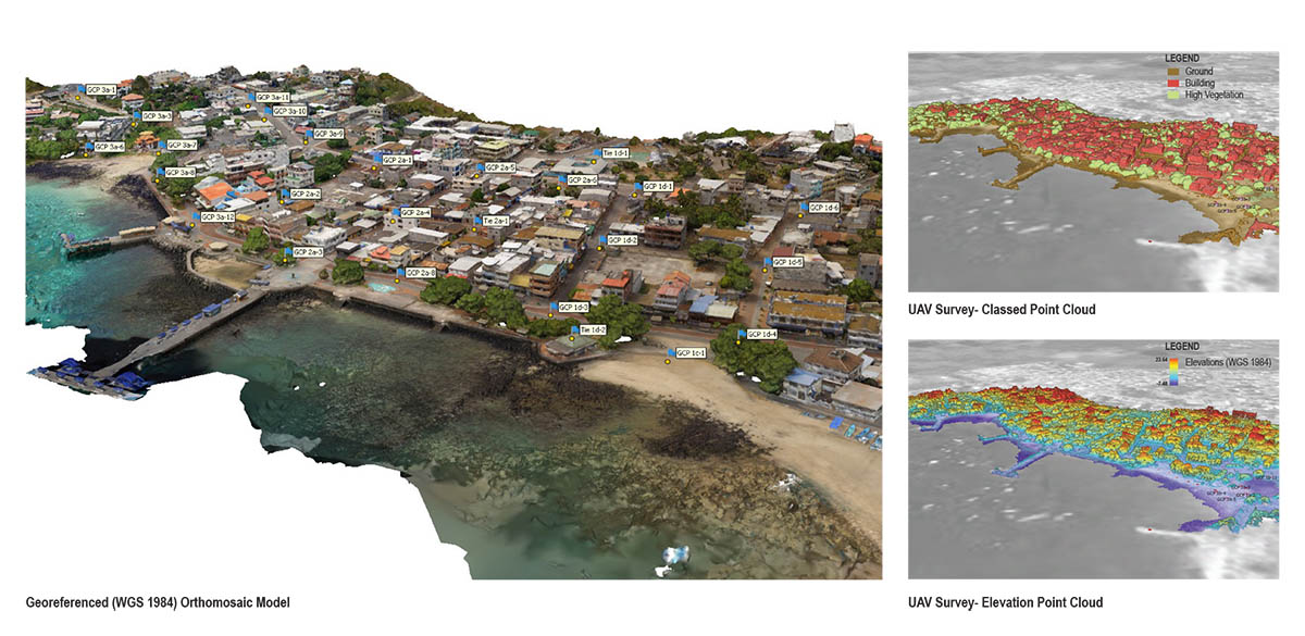
Accurate surveys are critical to understanding low-lying, flood prone locations. Surprisingly, the Galápagos Islands—one of the most scientifically studied sites in the world—lacks such data. Without a consistent and unified vertical datum, neither tides nor storm surge can be accurately referenced to the land; subsequent development into potentially vulnerable areas will increasingly put people in harm’s way. Consequently, we reached out to INOCAR (The Oceanographic Institute of the Navy in Ecuador, similar to the USA’s NOAA) to request this information, they instead asked for our assistance in the collection and registration of the gauge.
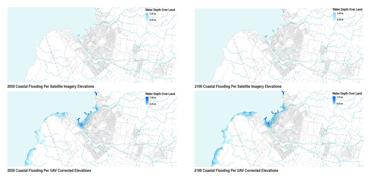
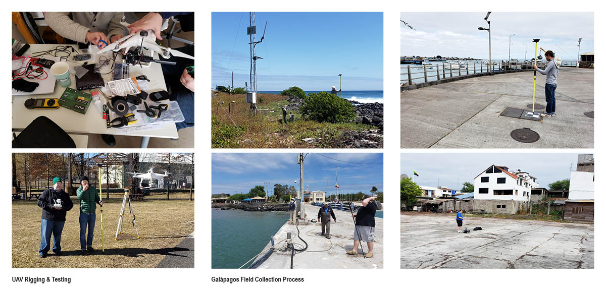
Our team used UAVs (drones) and GPS/ GNSS site survey equipment to record aerial survey information of Puerto Baquerizo Moreno’s shoreline and ravines. Over the course of four days, our team collected approximately 20 hectares of high accuracy survey data, including tide gauge location and elevation. The resultant model was delivered to INOCAR in the fall 2019. This information will be essential for modeling past and future storm surge, sea-level rise, and tsunami scenarios as it relates to the island’s urban growth and coastal areas. In the context of a changing climate and increased storm volatility, accurate survey data is critical to devise ways to lessen the potential impacts.
This projected included the participation of many key partners including residents and schools in Puerto Baquerizo Moreno, the Galapagos National Park, the Mayor’s office of San Cristóbal, the Charles Darwin Foundation, and the Oceanographic Institute of the Navy (INOCAR).

Fantasy Island: The Galápagos Archipelago
Lead Designer:
- PEG office of landscape + architecture (Karen M’Closkey + Keith VanDerSys)
Collaborators:
- Michael Weisberg
- Michel Luegering
- Michel Tantala
Interns/ Research Assistants:
- Dorothy Jacobs
- Andrew Ward
- Lucy Whitacre
- Yini Tang
Client:
- Charles Darwin Foundation
- INOCAR
Fantasy Island: The Galápagos Archipelago
All Photo/ Image Credits: PEG office of landscape + architecture (Karen M’Closkey + Keith VanDerSys)