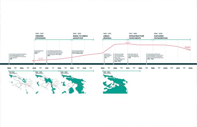
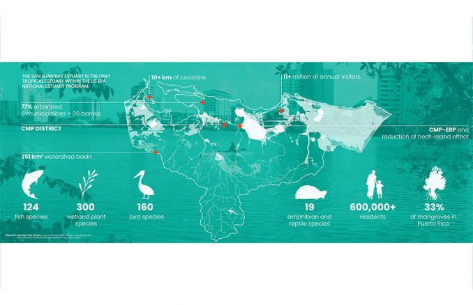
The Caño Martín Peña (CMP) District, a tapestry of eight communities located around a channel of the San Juan Bay Estuary, has proven itself to be both resilient and resourceful. Amidst a multitude of challenges, these communities have recognized the value of their shared social connections, harnessing their collective strength as a lifeline to survival and improved living conditions. Two decades ago, this commitment to solidarity coalesced into a unified coalition. They fought for their homes, their right to stay within their communities, and for improved infrastructure, along with greater environmental health and economic opportunities.
The Caño Martín Peña Comprehensive Infrastructure Master Plan (CIMP) was born out of this collective effort to tackle enduring environmental problems faced by the communities, especially in the context of the climate crisis. Building on the principles laid out by the 2004 Plan de Desarrollo Integral y Usos del Terreno: Distrito Especial Caño Martín Peña (PDI), the CIMP emerged as a proactive vision that effectively addresses environmental and social justice concerns. Developed through extensive collaboration with the coalition of the CMP District communities, the CIMP tackles the challenges posed by frequent flooding and a lack of adequate infrastructure.
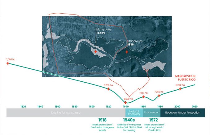
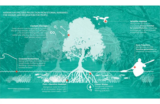
In response to these problems, the CIMP adopts a strategic approach, focused on reengineering the urban fabric and open spaces of the district to better serve the communities. It aims to mitigate the impacts of flooding from contaminated waters and to stop the discharge of sanitary sewage into the San Juan Bay Tropical Estuary, a region abundant in mangrove habitats.
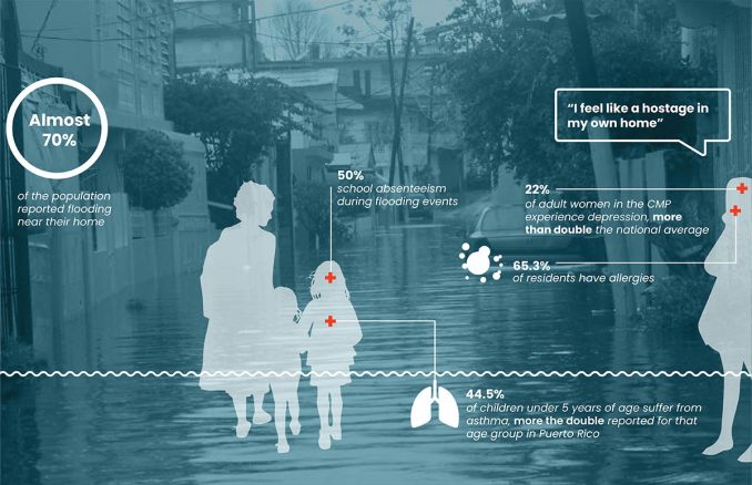
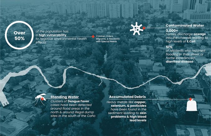
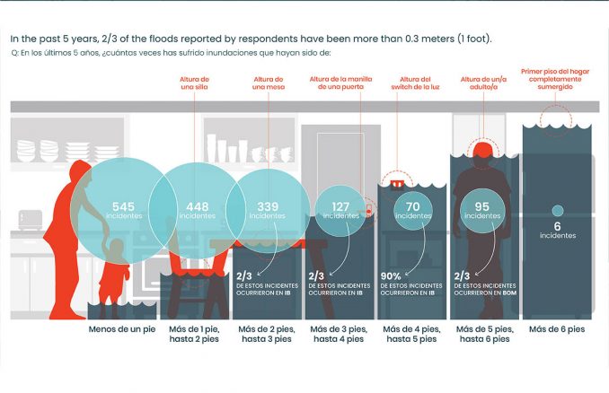
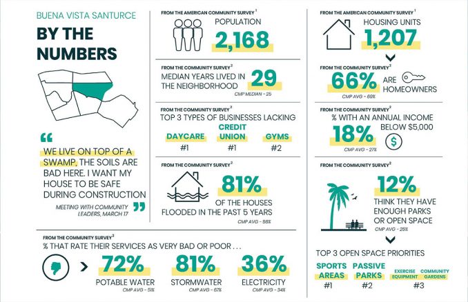
The communities themselves, having developed informally over unconsolidated fill layers and featuring a dense residential composition, are faced with several issues. An underserved water supply, failing sewer systems, a fragile electric grid, and a heightened frequency of flooding have resulted in significant environmental burdens. The risks are further amplified by seismic threats, creating an urgent need for comprehensive planning and action.
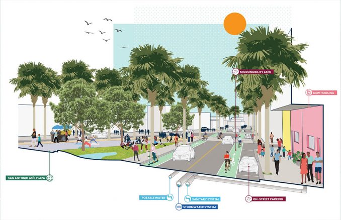
To address these issues, the CIMP has proposed a series of innovative solutions, starting with a housing-first approach. This initiative seeks to ensure the residents of CMP can remain within their communities, close to their social support networks. Collaborating with the community land trust, Fideicomiso de la Tierra, the plan proposes new housing models that are modernized and constructed above the flood elevation, enabling residents to relocate within their community safely.
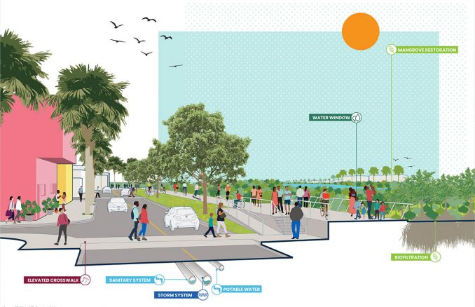
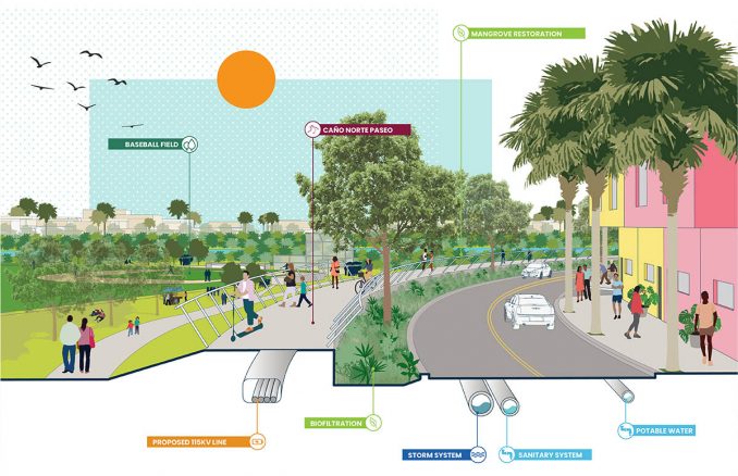
As the new housing policy takes effect, upgraded sewer and utility services will work towards protecting water quality. These services will incorporate nature-based green infrastructure solutions to manage daily runoff, thereby protecting the health of the mangrove estuary.
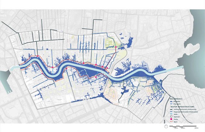
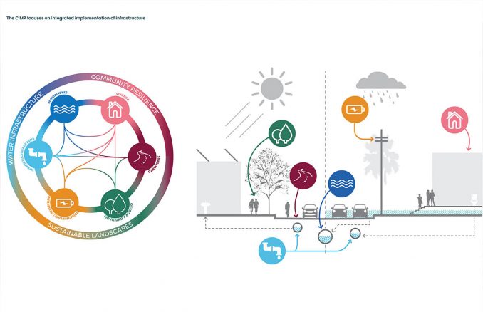
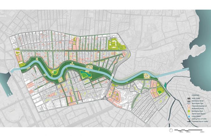
The CIMP further introduces modernized infrastructure integrated into two park promenades—named the Paseos—that sit along the North and South Banks of the stream channel connecting the San Jose Lagoon with San Juan Bay. The Paseos are designed to incorporate nature-based solutions, managing stormwater while providing engineered flood protection based on climate change risk analysis from the Intergovernmental Panel on Climate Change’s AR6 report. This comprehensive strategy targets safe drinking water, sanitary water and stormwater collection, flood protection, local solar power generation, economic opportunities, and access to safe housing and open spaces.
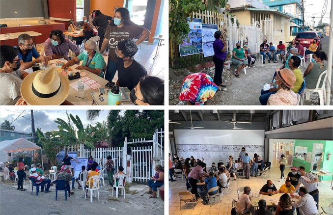
With an active community engagement at its core, the planning process is deeply democratic and inclusive. A cost-benefit analysis, built on the rigorous framework of FEMA Benefit-Cost Analysis, was developed to capture community values, measuring more than just property risk mitigation. The outcome of this analysis reveals a return of over two dollars of value for every dollar spent on mitigation, creating a powerful blueprint for future community-led initiatives.
Moreover, the CIMP is designed to be forward-thinking, preparing for climate impacts through actionable plans, scalable solutions, and the protection of biodiversity within the San Juan Bay Tropical Estuary. The plan is designed with the needs and aspirations of the CMP District communities in mind, laying the foundation for a sustainable, equitable, and resilient future that empowers residents and protects their social capital.
Caño Martín Peña Comprehensive Infrastructure Master Plan | OLIN
Designer Credit: OLIN
Client: Corporación del Proyecto ENLACE del Caño Martín Peña
Company Role on Project: Lead Landscape Architect
Collaborators/Other Consultants:
Architect and Local Landscape Architect: ECo Design Studio
Green Infrastructure: EDesign Dynamics, H-H Modeling
Local Water Resources Engineering: ARCADIS
Resilience Planner: SGD Urban Solutions, Resilience Planner
Economic Advisor: Barretto Bay Strategies
Ecologist: Ambienta Inc.
Energy Planning: ARUP
Transportation Engineering: VAG Transportation Engineering Consultants
Cost Estimator: VJ Associates
Structural Engineering: Jon Morrison & Associates
Local Electrical Engineer: JRR Engineers
Arborist: Palma Roja, INC.
Local Water Infrastructure Consultant: JTO Engineering