The River as Co-Author
Few cities are shaped as intimately by water as Hue. The Huong River is both a cultural spine and a living system whose rhythms define seasons, livelihoods, and the identity of the former imperial capital. Today, however, intensified rains, stronger typhoons, and accelerated riverbank erosion redraw the city’s edges each year, making climate resilience not an abstract ambition but a daily negotiation.
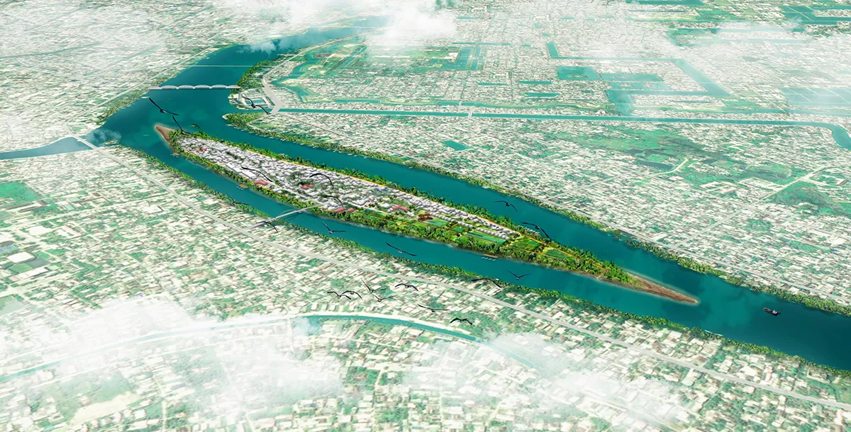
As part of the Global Covenant of Mayors (GCoM) Asia program, supported by the European Union, Hue initiated a comprehensive study on Nature‑based Solutions (NbS) to address flooding and erosion in an integrated manner. The study involved a consortium of OMGEVING, ISPONRE, and local government departments. Hen Dune, a densely inhabited island in the Huong River, emerged as the primary pilot site.
This article highlights the design research and spatial strategies developed for Hue, illustrating how ecological processes, community life, and urban governance can converge to create a resilient river landscape.
A City Under Pressure
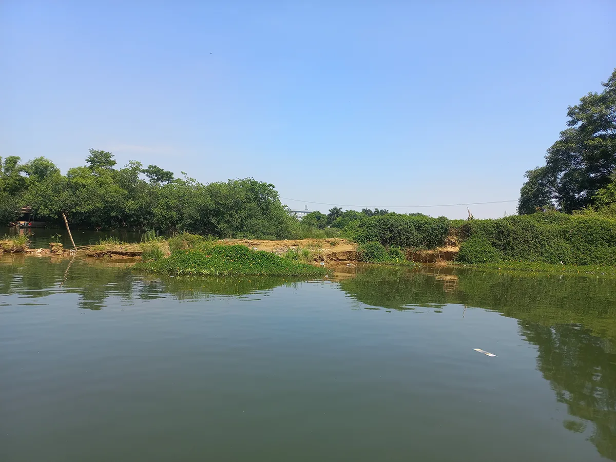
Hue’s geography blends mountains, lowlands, and a branching river network that courses through agricultural belts and historic neighbourhoods. The city’s permeable surfaces have shrunk due to construction and urban growth, while upstream rainfall events have intensified, amplifying flood peaks and accelerating erosion. Informal housing along riverbanks, especially on Hen Dune, magnifies exposure to climate hazards.
Hue’s Climate Action Plan sets mitigation and adaptation priorities, yet the pressures are clearest at the river’s edge. The erosion of Hen Dune’s head and tail, recurrent inundation, and the proximity of homes to unstable banks make the island a microcosm of Hue’s wider challenges.
Why Nature-based Solutions?
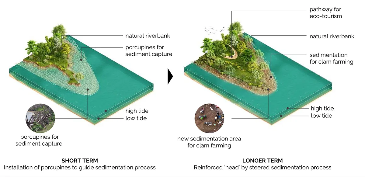
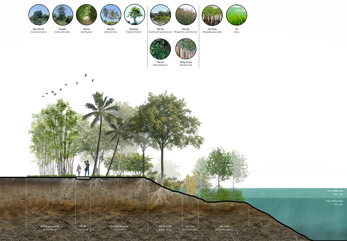
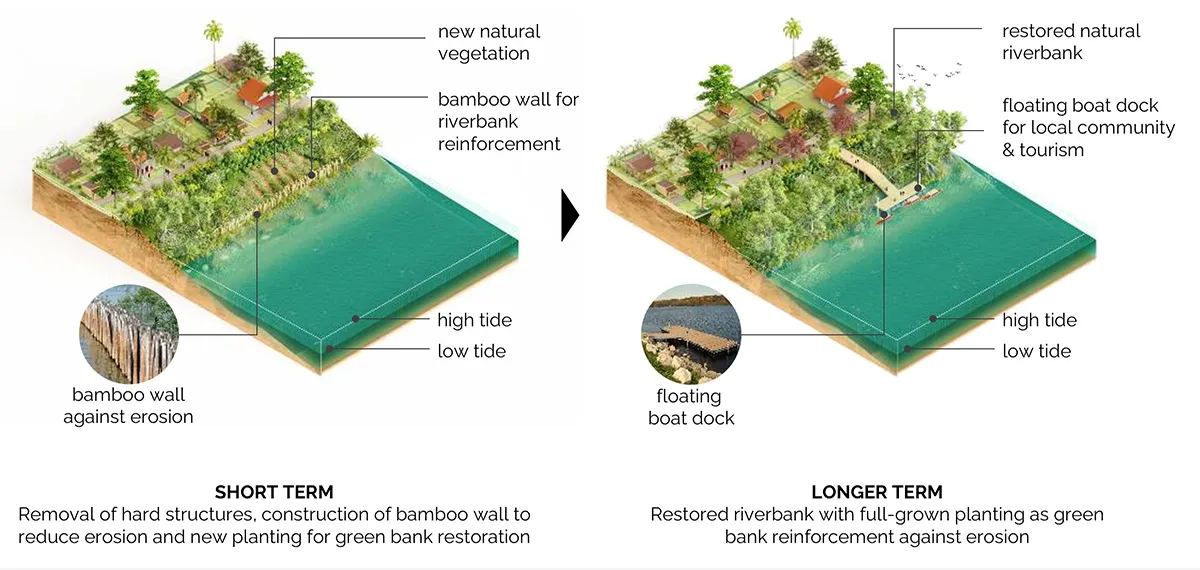
Traditional hard-engineered embankments often accelerate erosion downstream and degrade ecological quality. NbS offer an alternative by working with fluvial dynamics instead of resisting them. In Hue, several forms of NbS proved particularly promising. Porcupine structures, open, permeable assemblies, slow currents, and stimulate targeted sediment deposition. Bamboo walls, set slightly inland from the river edge, stabilise soils while allowing vegetation to return. Combined, these measures create a living riverbank that thickens and strengthens naturally over time.
Beyond physical stabilisation, NbS address ecological health, public space, and livelihood resilience. They are inherently multi-functional, turning the river edge from a defensive line into a place for mobility, recreation, and production.
Selecting a Pilot: Why Hen Dune?
The study initially evaluated three potential pilot areas: Bach Yen Riverbank, Ton Duc Thang Park, and Hen Dune Island. Using criteria such as resilience impact, technical feasibility, socio‑economic benefits, and potential for replication, Hen Dune emerged as the preferred project site. With over 1,000 households living on only 2,4 hectares, the island faces concentrated exposure to erosion and floods, yet also holds a patchwork of agricultural land, natural bank segments, and strong community ties that make it an ideal site for demonstrating integrated NbS strategies.
Designing an Adaptive Island
The design vision for Hen Dune orbits three thematic strategies: rebuilding the ecological edge, improving connectivity, and creating safer, more liveable living conditions.
Strategy 1: Restoring the Ecological Edge
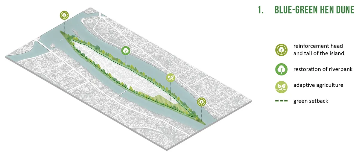
Erosion at the island’s extremities has intensified in recent decades. The design proposes installing porcupine structures at the head and tail to allow the river to deposit sediment in controlled patterns. Over time, these mudflats act as nurseries for native vegetation and create a buffer that helps stabilise the island’s form. Bamboo walls reinforce this system by creating a permeable, planted embankment further inland.
A crucial spatial principle is the introduction of a green setback, a 15 to 20 metre building-free river margin across the island. This open strip, to be formalised in the upcoming urban master plan, protects the restored banks from new encroachment, ensures maintenance access, and forms the foundation of a future public riverfront.
Within the island’s interior, farming plots transition to flood-adaptive agriculture. Existing practices of seasonal inundation are reinforced, and opportunities for expanding clam farming, already rooted in local culture, are created in new sediment zones. This integration of ecology and livelihood ensures that NbS not only reduce risk but also generates socio-economic value.
Strategy 2: A Connected Island: Water and City

Hen Dune’s future hinges on better connections with the rest of Hue. Today, informal boat landings provide limited and sometimes unsafe access. The proposed network of public boat docks regularises and improves water-based mobility for residents and visitors. These docks align with the green setback, where a continuous park loop creates small public spaces, sitting terraces, and pedestrian routes along the restored banks.
Longer-term mobility improvements include upgrading the main internal roads and eventually renewing the bridge linking the island with the southern bank. These upgrades support both everyday accessibility and evacuation routes during extreme weather events.
Strategy 3: A Liveable Island: Housing, Safety and Social Infrastructure
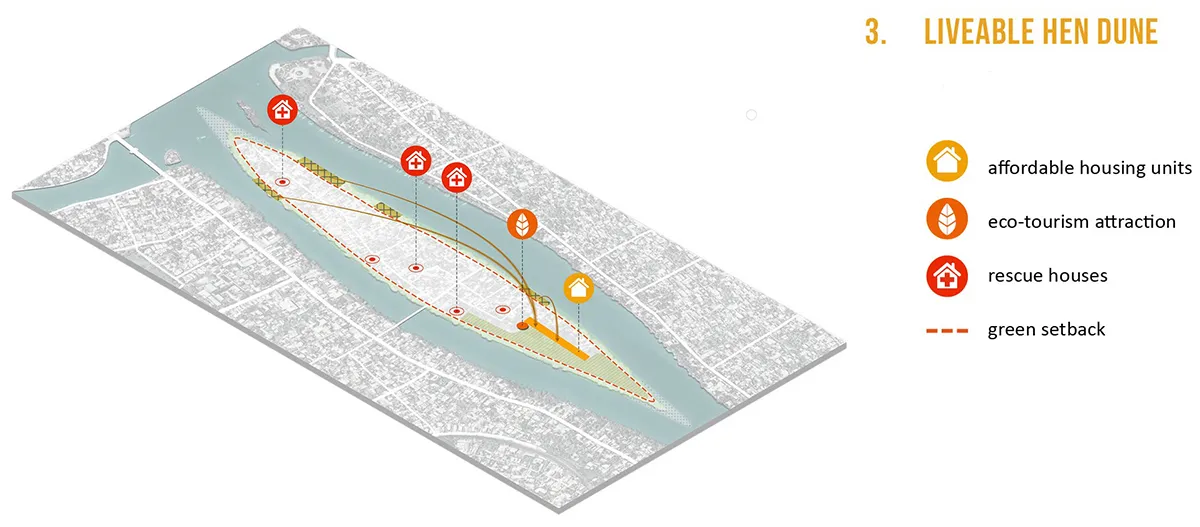
Restoring the riverbank requires relocating homes built directly against the eroded edge. The design proposes new clusters of affordable, elevated homes on higher ground along the agricultural zone. Their lightweight construction and raised floors provide safe, dignified alternatives that preserve community proximity.
To improve emergency preparedness, a network of multi-functional rescue houses is introduced. Each two-storey building serves as a community hub in normal circumstances and offers safe refuge during floods, with upper levels elevated above recorded flood peaks. These structures form an essential layer of social resilience and ensure that emergency infrastructure has meaningful everyday value.
How NbS Work: Materials and Process
The NbS applied in Hue draws on accessible materials and local know-how. Porcupine structures, lattice frameworks placed along and across the flow, initiate siltation and gradually build new land. In some Vietnamese regions, bamboo variants of these structures have proven effective in aquaculture settings, offering low-cost and environmentally benign solutions. Bamboo walls combine simple timber components with geotextiles and dredged soil to form a permeable bank section that supports layers of vegetation. Over time, root systems enhance bank stability, habitat value increases, and heavy embankments become unnecessary.
What NbS Mean for Urban Life
The NbS strategies developed for Hen Dune fundamentally alter how risk, ecology, and community life intersect. Instead of fighting the river, the proposals choreograph its processes: allowing sediment to accumulate where needed, vegetation to anchor new land, and public space to emerge from repaired ecological systems. For residents, resilience becomes visible not as a barrier but as improved access, safer homes, and more vibrant communal spaces.
NbS also demonstrate that climate adaptation does not need to separate ecological restoration from socio-economic development. On Hen Dune, erosion control supports aquaculture; adaptive agriculture enhances local identity; and rescue houses double as public amenities. This fusion of everyday value and climate-readiness is key to long-term community support.
Scaling Up: From Pilot to Citywide System
Although Hen Dune is the first pilot, the study identifies multiple riverbank segments across Hue where similar NbS strategies can be applied. Embedding the green setback and NbS principles into the forthcoming urban master plan ensures continuity beyond a single project site. Over time, Hue can develop a citywide blue-green network where restored banks, adaptive farms, public spaces, and ecological corridors form an interconnected landscape system.
Conclusion: A River City Learning to Breathe
Hue’s future resilience will depend on how it chooses to live with the Huong River. The NbS study shows that by listening to the river’s dynamics and working with its sediment, currents, and vegetation cycles, urban resilience can grow from ecological intelligence rather than infrastructure alone. Hen Dune becomes a model not of fortification, but of adaptation: a place where the river is not the enemy but a partner in shaping a more ecological, connected, and liveable urban island.
Article by OMGEVING
Image and text credits: OMGEVING