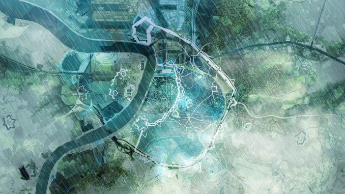
Our climate is changing. The consequences of the climate crisis are no longer abstract, but frequently noticeable in our urban environment. Rain will fall more often in short periods with a very high intensity. We also experience longer consecutive periods of drought and high temperatures. Due to climate change, our cities are facing serious social, ecological and economic challenges. At the same time, these challenges offer the opportunity to shape a sustainable future for our urban environments. The Waterplan for Antwerp gives an inspiring vision of how the city can approach future projects to be ready for a climate with larger extremes.
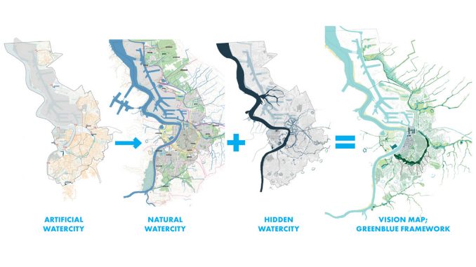
In the Waterplan Antwerpen, three ‘watercities’ are described; The artificial watercity (the current sewage system of the city), the hidden watercity (the historical, often disappeared traces of water in the city) and the natural watercity (the natural water channels and green areas in and around Antwerp). Main ambition of the Waterplan is to move the focus from the artificial watercity towards the natural watercity and bring back historical water traces where possible within one city-wide vision.

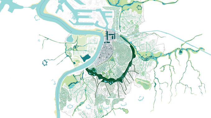
The three watercities together form the base for the layers of the Waterplan vision map. In this vision we created a framework that consists of five main waterstructures. These structures are the result of the historical natural and urban growth of the city. The five structures together are redefined as the blue-green framework for Antwerp.

For each of these water structures, a specific rainwater cascade is developed which helps achieve the Waterplan Antwerpen ambitions. We provided the rainwater cascades with applicable water sensitive measures. This cascade starts with measures for infiltration, buffering and reuse on private grounds and their surrounding public spaces. Then the water flows towards neighborhood facilities like local rain gardens and water squares. After that, larger buffers in parks follow and finally the enlargement of embankments of stream valleys is activated. The result of these various measures is that no stormwater disappears into sewage pipes anymore.
To test the theory of the Waterplan we worked out exemplary cases. One specific case aims to run through a complete water cascade from private grounds to the stream valley, while optimally utilizing the existing topography for gravitational water transport between its beginning and the endpoint. This case has been hydrologically modeled and its proposed dimensions of water sensitive measures are geared to accommodate future peak rain events.
The Waterplan Antwerp is ratified by the municipality, budgets have been allocated and follow-up actions have been defined. Due to an interactive process with stakeholders of nearly two years, the Waterplan Antwerpen is embedded into a broad range of city departments, utility companies and regional governmental institutions. The Waterplan narrates a hydrological and spatial blueprint for the city and also frames the transition from existing design strategies to implementation processes for the coming decades. Water is used as a leverage to redesign Antwerp, focusing on the challenges of flooding, and integrating various climate adaptation strategies while substantially greening the city too.
Waterplan Antwerpen
Location | Antwerp, Belgium
Landscape Architect | DE URBANISTEN
Collaboration | Witteveen+Bos Belgium, Common Ground
Year | 2018-2019
Client | City of Antwerp
Images & Text Credit | DE URBANISTEN


