Typical of San Francisco Bay in general, San Pablo Bay is structured by parallel rocky, fault-generated ridges and soft alluvial lands between them where water collects and flows. We are facing decades, if not centuries, of both coastal flooding and seismic liquefaction of soft ground – one incremental by nature, the other instantaneous. But current settlements in California are only 150 years old. Flat and compliant, shoreline marshes and mud flats have been an easy place to construct infrastructure – highways, railroads, airports, and refineries. This project is about adapting our lives and our infrastructure within these fertile and biologically diverse lands frequently degraded by marginal human uses and unstable fill.
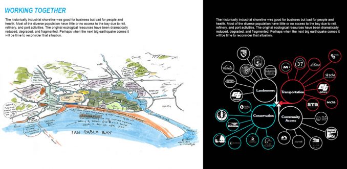
These lands are also the home for many people, including some of the most disadvantaged neighborhoods in the Bay Area, who frequently have no voice in their future. Shoreline communities and infrastructure are at the front line of sea level rise and seismic challenges throughout the Bay Area and the Pacific Rim. City and regional leaders need a plan, not just for how to patch flooding problems, but for how to grow their cities along their shorelines by focusing much more on people, habitat, and healthy connections with the Bay. Informed by multidisciplinary research, numerous stakeholder engagement and community participation, our team took upon this task as part of Resilient by Design-Bay Area Challenge.
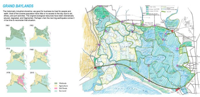
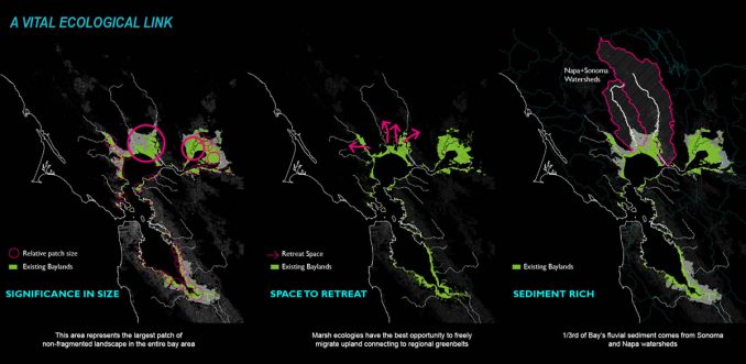
The project demonstrated the adaptation strategies for an area larger than San Francisco. As these areas have been manipulated for human use over the last 150 years, they have frequently been diked off from bay waters and tidal fluctuation. The protagonist in this project – State Route (SR) 37 sits atop one of these levees. Large areas of the San Pablo Baylands were converted to agriculture in this way. Cut off from tidal exchange and watershed runoff, they gradually subsided due to soil depletion from farming and lack of natural sediment deposits – similar to what we see in the Mississippi Delta. Some zones are now 7-8 feet below sea level and the entire area is at risk of becoming open water and losing much of the ecological function and recreational value.
Design Goals
The team held and attended events in communities bordering the baylands to solicit input at local farmers markets, the annual San Francisco Bay Flyway Festival, local schools, libraries, and in the baylands themselves. Some of the main themes that appeared in these conversations and online feedback centered around traffic, resiliency, and the recreational and ecological resources the baylands offer. Their excitement about future guided tours and educational opportunities, improved pedestrian and bike trails, more water access and bird watching options, and new picnic and camping areas was noted. These conversations, along with the feedback from North Bay communities, provided clear mandates and standards by which we could measure our design proposal in four key areas:
- Identity: Strengthen the identity of the San Pablo Bay region to encourage better understanding of the baylands as a major ecological and educational resource
- Adaptation: Provide new strategies for adaptation of the San Pablo Baylands in response to sea level rise.
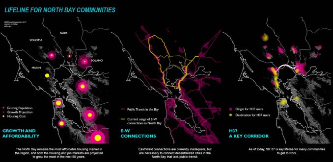
- Mobility: Deliver long-term intermodal connections around and across the San Pablo Baylands.
- Access: Provide more equitable access to the communities of San Pablo Bay, with particular attention given to programs for disadvantaged communities to broaden the constituency for the baylands.
Grand Bayway – moving in a resilient landscape
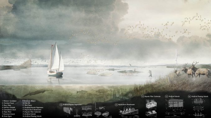
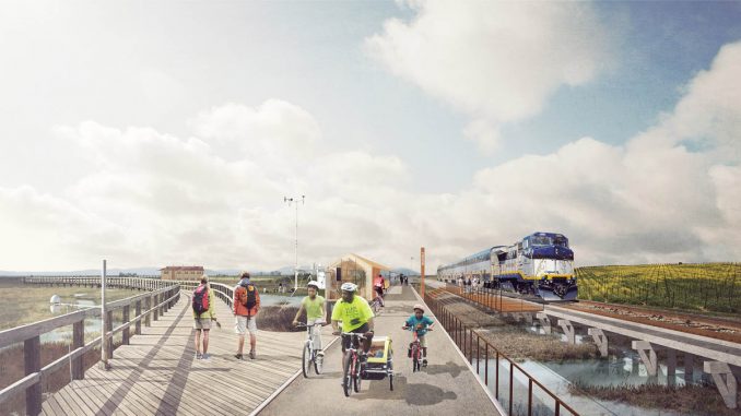
Understanding the urgency of a functional highway and opportunity of restoring these wetlands, the design proposes an adaptation strategy for SR 37 that incorporates the objectives of conservationists and transportation planners. It pledges to provide agency to a larger constituency of North Bay communities seeking increased equitable public access to the baylands adjacent to SR 37. To this end, the team offered a strategy to elevate the highway so it would reduce flood risk, expand vehicle capacity, offer additional opportunities for public access to the baylands, and provide unconstrained ecological and hydrological connectivity. Taking cues from the USFWS Roadway Design Guidelines and an array of international precedents, the project proposes a new SR 37 that would be more responsive to landscape features and ecological processes. Serving as a “front door” to a vast ecological common, the highway would provide access for the diverse communities of the North Bay to additional programming and facilities for cyclists, runners, kayakers, campers, and fishermen.
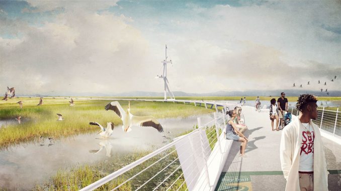
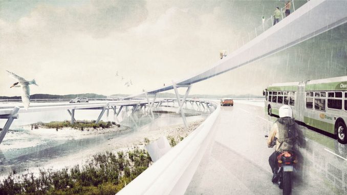
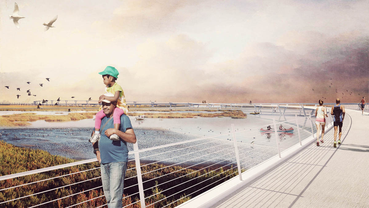
This “Grand Bayway” is designed with the same ambition and flair as other iconic bay crossings but based on 21st century sensibilities for the natural environment and diverse transit types. It is based on the principles of scenic byway design, curving to open views over the bay and marshes and oriented to natural landmarks like Mt. Tamalpais, Mt. Diablo, and Cougar Mountain. The sinuous and meandering profile of the causeway not only curates viewsheds of distant features but the elevated vantage also affords an entirely different reading of the landscape textures than from the ground. Conceived as a rhythmically delaminating roadway, lane directions as well as the Bay Trail are “unspooled” and flow independently like the sloughs they traverse. The causeway “touches down” at a series of strategically placed amenities, offering more intimate and immersive opportunities to interact with the bayland terrain.
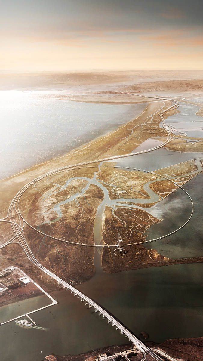
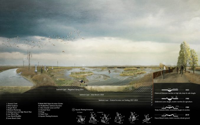
This terrain is of course inextricably linked to the resolution of the highway. To prepare for rising sea levels, the project proposes to create an ecological laboratory working strategically with streams and diked sloughs to incrementally re-engage sediment deposits and cultivate biodiversity though various means including “sediment trains,” hyper-accretion gardens, and floating wetlands. While the Napa River and Sonoma Creek provide roughly a third of all sediment entering the Bay today, these rich sediment resources are currently trapped by leveed sloughs and bypass the subsided former farmlands that need sediment the most. With the challenge of a sediment deficit and a dearth of time to prepare land for sea level rise, the team focused research on finding more innovative ways to design ways to take advantage of flood events to redirect sediment to existing marshes and future areas for transition and retreat.
The Grand Bayway | San Pablo Bay, California | TLS Landscape Architecture
Landscape Architect: TLS Landscape Architecture
Lead Designers: Tom Leader, Kushal Lachhwani, Erik Prince
Consultants: Exploratorium | Guy Nordenson & Assoc | Michael Maltzan Arch| HR&A Advisors | Sitelab Urban Studio | Lotus Water | Rana Creek | Dr. John Oliver | Richard Hindle, UC Berkeley | Fehr & Peers Transportation Consultants