The Henghe Coal Mine subsidence area, located in Zoucheng City, Shandong Province, China, is subject to a continental monsoon climate with limited precipitation and harsh winter conditions, resulting in constrained biodiversity. Historically, this region has been an intensively cultivated agro-landscape for over a millennium. However, the project site (total area 4.71 km2) has experienced a decline in crop yield due to continuous underground coal mining operations since the early 1970s. Beginning in the 1980s, the farming area began to exhibit subsidence and deformation due to mining activities, leading to the loss of arable land and necessitating the relocation of rural residents.
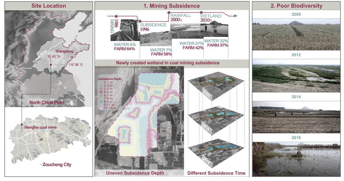
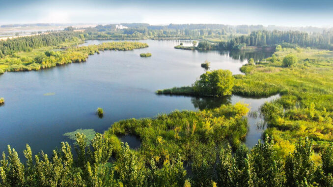
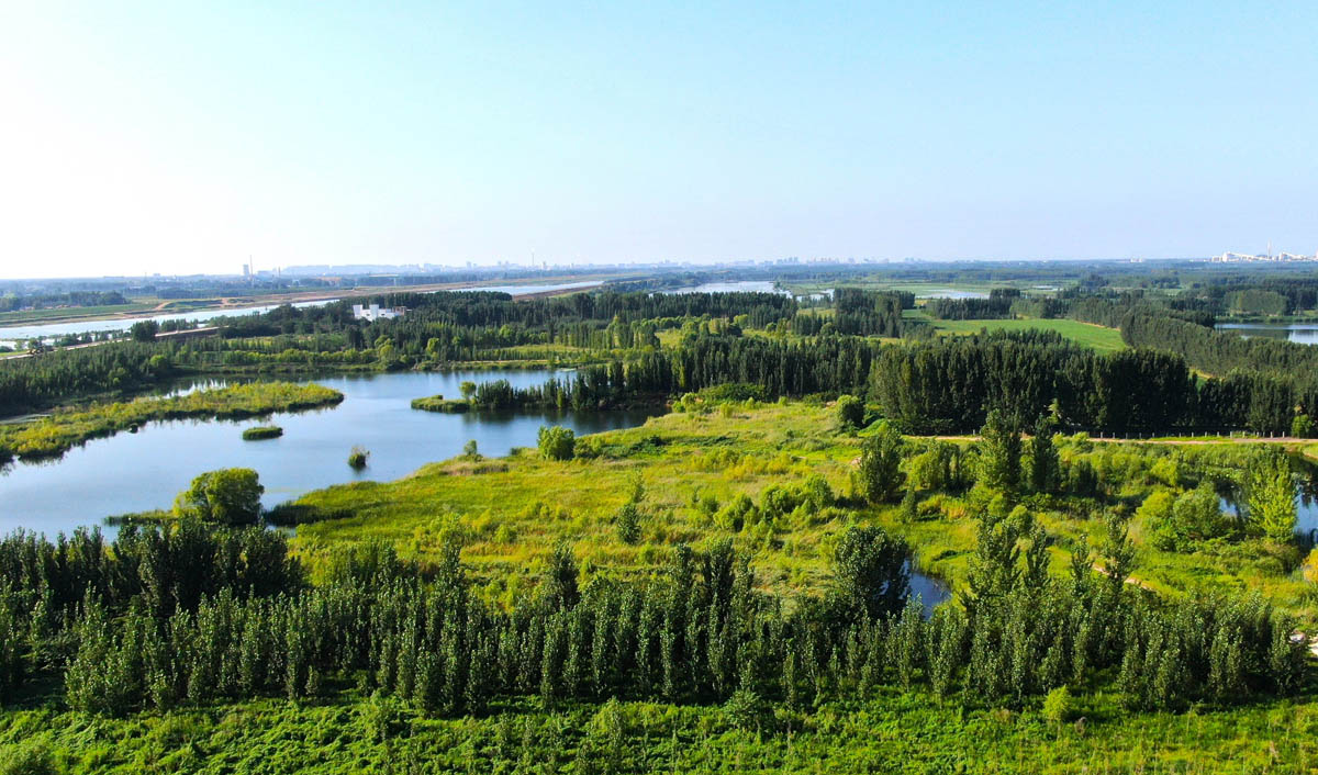
It is noteworthy that groundwater upwelling and rainwater accumulation, induced by land subsidence, have resulted in surface water ponding and the proliferation of wetland vegetation, thereby creating new wetlands within coal mining subsidence areas. These emergent wetlands offer ecological potential for rainwater storage and drought mitigation. They also provide favorable conditions for the growth of wetland flora and fauna, including fish and waterfowl, thus presenting unique opportunities to enhance biodiversity.
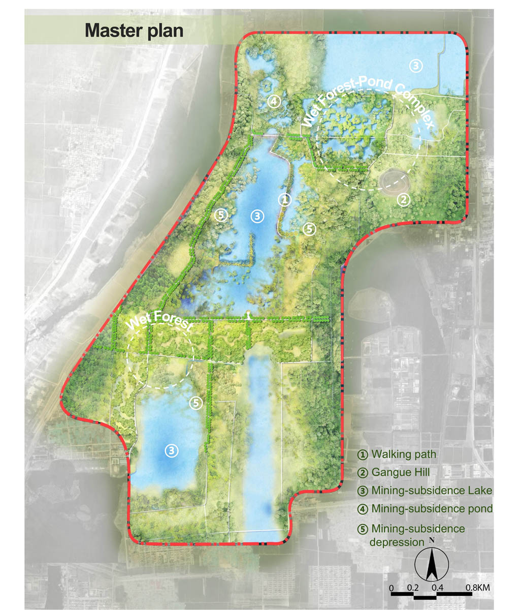
To fully exploit the ecological potential of these newly formed wetlands within the subsidence area and to transform the biodiversity-depleted farming landscape into a living landscape adapting to the dynamic subsidence process, we propose the following strategies:
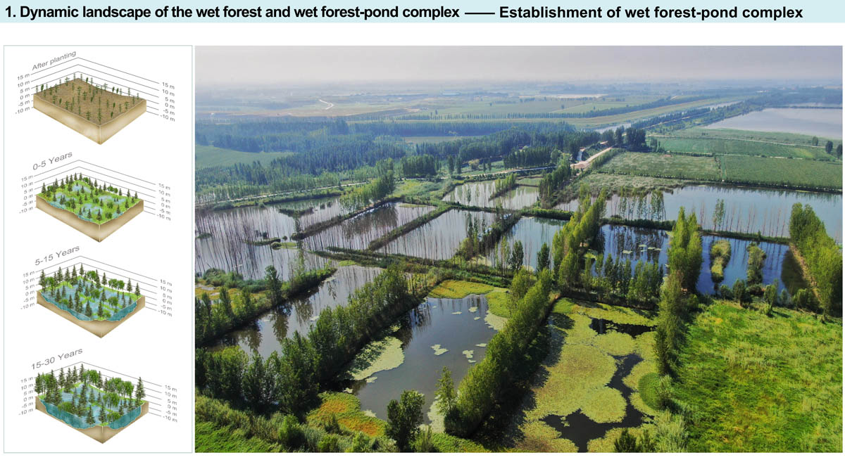
Dynamic landscape of the wet forest and wet forest-pond complex
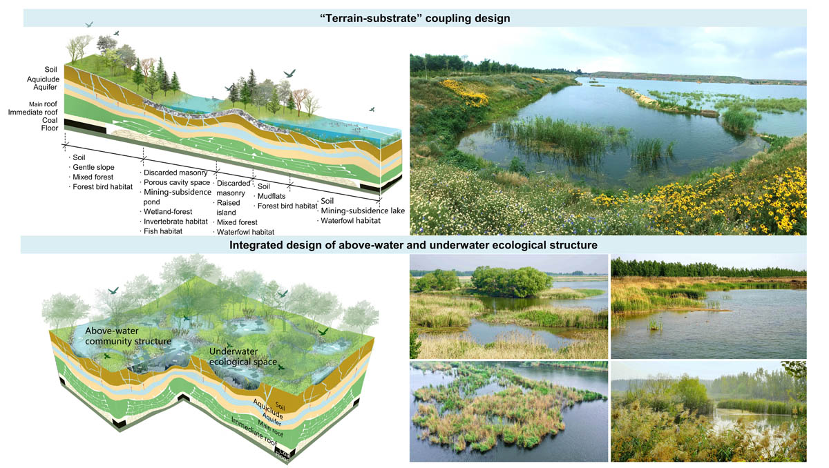
Variations in the subsidence stage, substrate characteristics, and soil composition have resulted in spatiotemporal heterogeneity within the mining subsidence area. Three subsidence stages are observed: (i) 0-5 years, with a subsidence depth of 1-2 m; (ii) 5-15 years, with a subsidence depth of 2-4 m; and (iii) 15-30 years, with a maximum subsidence depth of 5-7 m.
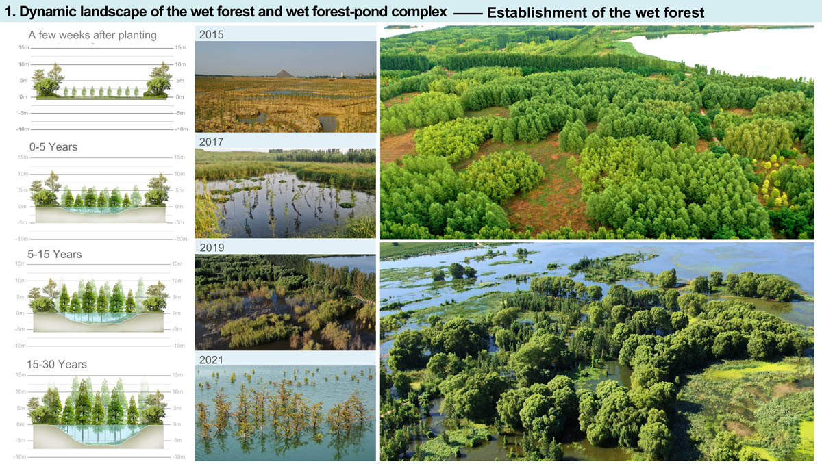
Wet forests and a wet forest-pond complex were constructed to adapt to the dynamic land subsidence process. Flood-tolerant and moderately drought-tolerant trees (e.g., Triadica sebifera, Salix matsudana, Taxodium distichum, T. distichum var. imbricatum, T. ‘Zhongshanshan’) were planted in the predicted subsidence farmland.
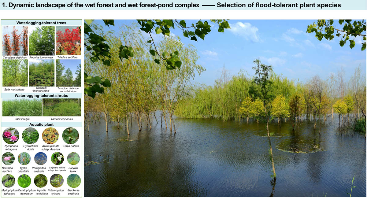
Furthermore, wet forests were designed to include forest gaps of varying sizes. Economic aquatic plant species, such as Euryale ferox and Trapa natans, were cultivated within mining subsidence ponds and depressions. The dikes surrounding these water bodies were backfilled with construction debris from demolished village houses and planted with flood-tolerant tree species. These trees are expected to reach heights exceeding 10 meters, while the land is projected to subside by 5-7 meters over 30-40 years, resulting in the formation of wet forest and wet forest-pond complex.
Multispecies collaborative new wetland in subsidence areas
Habitat restoration efforts are tailored to accommodate variations in subsidence depth, subsidence duration, and the habitat requirements of biotic communities. The establishment of diverse newly created wetland types, including mining subsidence ponds, depressions, and lakes, as well as the cultivation of species-rich plant communities, serves to enhance spatial heterogeneity and provide essential resting, sheltering, and breeding habitats for aquatic invertebrates, fish, and water birds. By designing habitats to promote multi-species symbiosis, food web complexity and ecosystem health are enhanced within these newly created wetlands, thereby promoting biodiversity within the coal mining subsidence area.
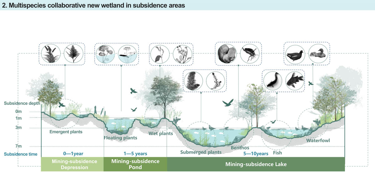
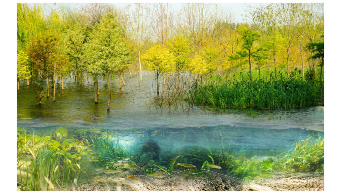
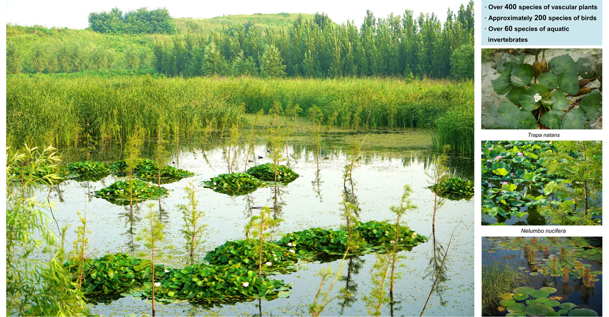
Efforts were made to preserve the original topography and substrate characteristics at different stages of subsidence in order to maintain spatial heterogeneity. Bricks and stones from demolished houses were repurposed as backfill within subsidence areas, creating underwater porous structures to serve as fish habitats and constructing islets above the waterline to provide resting and breeding habitats for waterfowl. The wet forest-pond complex, in conjunction with spontaneous plant communities, have formed an integrated above-water and underwater ecological structure, providing diverse habitats to meet the resting, sheltering, and breeding requirements of wildlife. The restored species-rich communities also function as significant carbon sinks with a carbon sequestration capacity of 11.84 t/hm2.
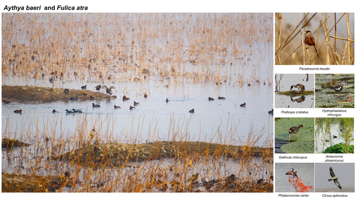
The restored area now supports over 400 species of vascular plants and approximately 200 bird species (e.g., Podiceps cristatus, Gallinula chloropus, Hydrophasianus chirurgus), representing a significant increase from the 70 plant species and fewer than 30 bird species recorded within the original, unrestored site. Significant populations of overwintering waterfowl have been observed within the restored area, including more than 40 species and over 20,000 individuals. Notably, the population of Aythya baeri , a species classified as Critically Endangered on the IUCN Red List and designated as a First-class protected wild animal in China, is estimated to exceed 200 individuals at the site.
Biodiversity-driven green products
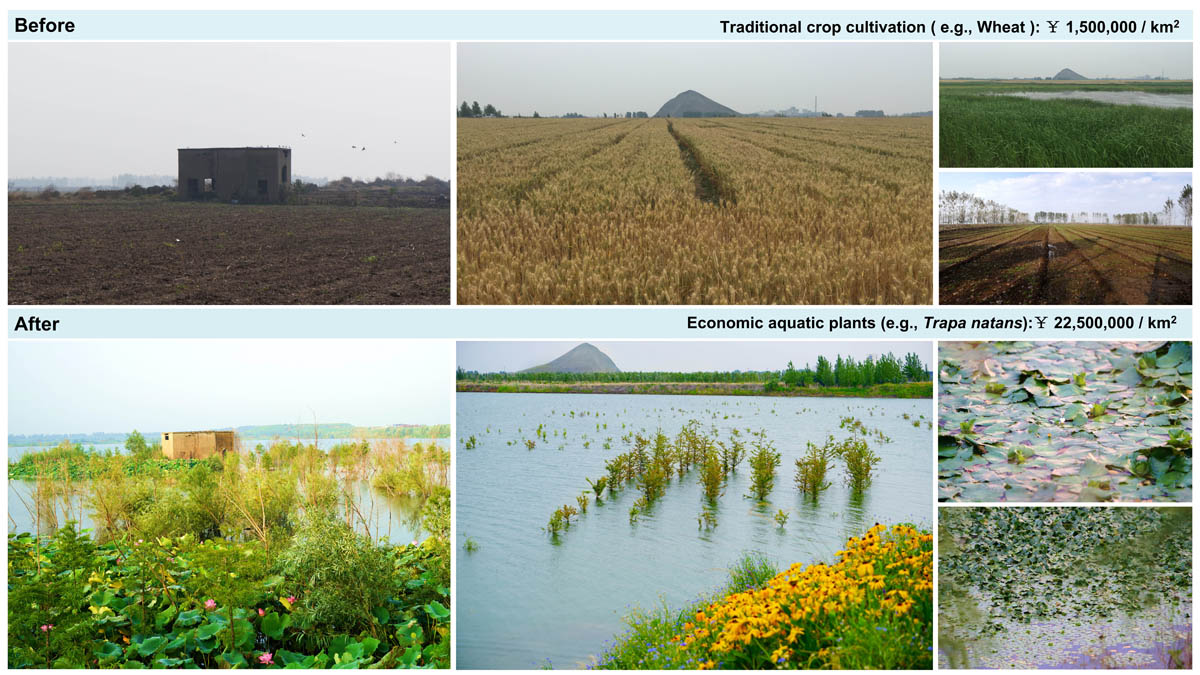
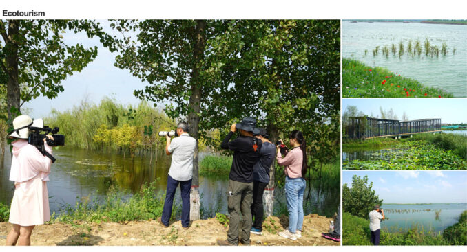
The diverse newly created wetlands in coal mining subsidence areas provide ecological products and services to local communities. These visually striking wetlands serve not only as popular leisure destinations and educational resources for science popularization but also as lucrative ecotourism sites, thereby contributing to the economic well-being of local residents. For example, the cultivation of economic aquatic plants such as Trapa natans within mining subsidence ponds can generate an economic value of 225,000 CNY per hectare, representing a significant increase over traditional wheat cultivation (15,000 CNY/hm2). Therefore, the living landscape of the newly created wetlands in the Henghe Coal Mine was awarded a “Public demonstration site for green products in China” by the Ministry of Natural Resources of the People’s Republic of China.
Conclusion
Overall, the newly created wetlands within coal mining subsidence areas has facilitated the creation of conservation zones and the restoration of biodiversity, while also enhancing ecosystem services such as water conservation and carbon sequestration. These wetlands provide a range of green products that contribute to the sustainable development of rural communities.
Through the ecologically responsible utilization of these new wetland resources, a once biodiversity-depleted coal mining landscape within the farming region of the North China Plain has been transformed into a thriving ecosystem with significant carbon sequestration and water conservation potential. This project is considered a best practice for biodiversity conservation and green development in coal mining subsidence areas.
Rebirth of coal mining subsidence area: from biodiversity-poor area to life paradise
Design Firm: Chongqing University
Designer Name:
Jia Yuan, Design Director, Chongqing University;
Ting Tang, Landscape Architect, Chongqing University; Hongfei Chen, Ecologist, Chongqing University;
Lu Ren, Landscape Architect, Chongqing University; Zhanfei Zhang, Landscape Architect, Chongqing University; Fan Tang, Landscape Architect, Chongqing University; Yuan Mao, Landscape Architect, Chongqing University; Chaofan Zhang, Landscape Architect, Chongqing University Xingzhong Yuan, Consultant, Chongqing University;
Xin Huang, Builder, Forestry Protection and Development Service Center of Zoucheng City, Shandong Province
Yumei Jiang, Builder, Forestry Protection and Development Service Center of Zoucheng City, Shandong Province
Qingming Zhang, Builder, Forestry Protection and Development Service Center of Zoucheng City, Shandong Province
Shaoan Dong, Builder, Forestry Protection and Development Service Center of Zoucheng City, Shandong Province
Guangjie Chang, Builder, Forestry Protection and Development Service Center of Zoucheng City, Shandong Province
Collaborators: Forestry Protection and Development Service Center of Zoucheng City, Shandong Province, Client; Pucao (Chongqing) Ecological Environment Technology Ltd., Consultant Company
Image Credits: Chongqing University