The city of Toronto is undergoing waterfront revitalization on a massive-scale. However, there is still a lack of focus on the primary issue: connectedness between the downtown core and the waterfront. In 2014, the Young Leaders division of the Toronto chapter of the Urban Land Institute issued a call for ideas relating to this very question: How would you better connect Toronto with its waterfront?
When considering Toronto’s waterfront, the conversation must address two major barriers. The first barrier is the Gardiner Expressway. The elevated expressway runs east-west parallel to Front Street and the water’s edge and acts as a physical and psychological barrier bisecting the city from the waterfront. The Gardiner, as it’s affectionately known, is a highly contested issue in itself and has been the subject of many studies and competitions in the past. In the interest of creating a vision for Toronto’s possible future, the Dillon Consulting Limited (Dillon) team made an assumption that in 100 years it is expected that the Gardiner Expressway will be replaced by transportation improvements that balance modes and encourage more sustainable commuting patterns, eliminating the need for an elevated expressway and providing an opportunity to reimagine the iconic structure.
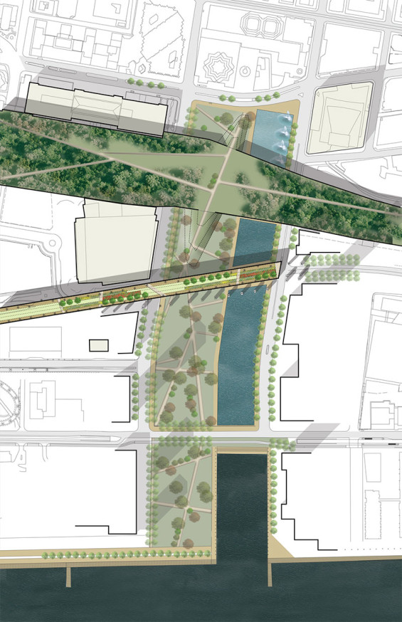
The second barrier to address is arguably the more critical in terms of functional connectivity: the rail corridor. The rail corridor runs parallel to the Gardiner. It is located below grade in a deep open trench in the western portion of the site and elevated on a berm to the east. There are very few pedestrian connections across it which limits the potential for connection to the waterfront at a human scale. The Dillon design team reconsidered this barrier and its natural topographic condition east-west through the study area as the key stitching agent across the site.
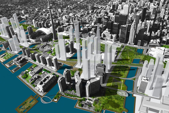
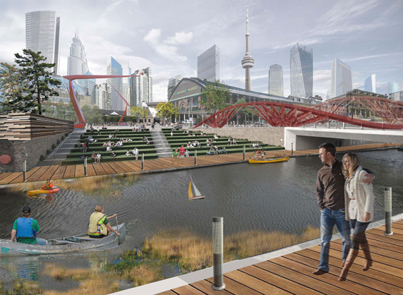
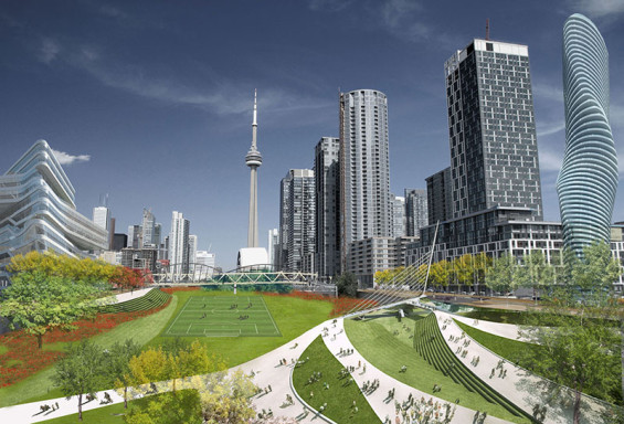
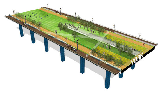
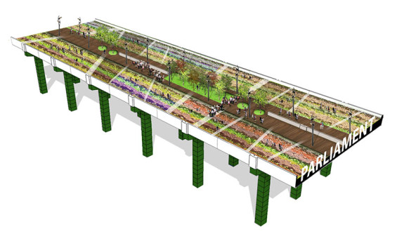
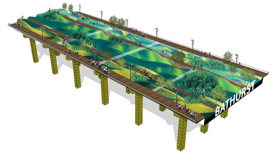
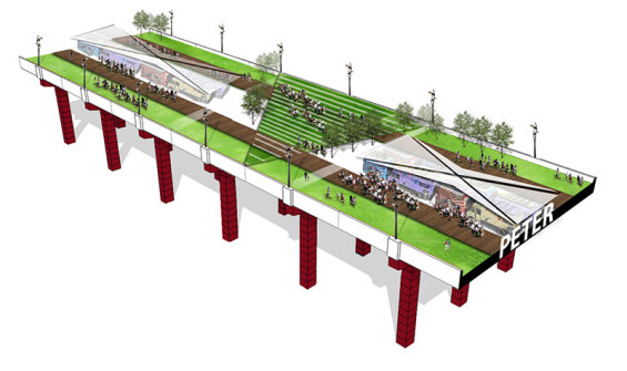
“Inundation,” the winning entry from Dillon, recognized that the Toronto waterfront had typically been studied as an east-west linear corridor along the water’s edge; however, that strategy can reinforce its segregation from the city centre. Inundation is an exploration of how to reprioritize the driving forces of change on Toronto’s Central Waterfront to focus on north-south relationships. The concept of Inundation introduces powerful strategies to prioritize public open spaces in the Central Waterfront, while maintaining expectations for development over the next 100 years. Inundation works to reintroduce the City with its majestic lakefront through the use of a series of north-south canals and linear parks that extend to the Lake’s original shoreline along Front Street. These canals create new parcels with waterfront access and provide opportunities for sustainable stormwater management. The overall concept also includes the introduction of an east-west park network situated over the rail corridor: a “park deck”. The concept of Inundation also looks to enhance way-finding by creating moments where the original elevated Gardiner structure is maintained and converted into cultural and thematic nodes for pedestrians that take advantage of the unique views from the Expressway. These elevated podium parks preserve the visual experience of being raised above the city floor to appreciate different views and gain orientation. The combination of public realm improvements creates an accessible and powerful sense of place to the Central Waterfront, while allowing inspired waterfront development to continue.
In addition to the benefit of providing a stronger connection visually between the city and the lake, Inundation creates a functional relationship between the two. By providing greater access to the lake in closer proximity, development can take advantage of the water for district heating and cooling systems. The channels provide an opportunity to create new fish habitat, redirect and filter stormwater before it reaches the lake, and act as detention ponds in the case of severe flooding events. The visual, functional and sustainable relationships fostered between lake and city in Inundation provide the rationale behind our bold transformation of the Toronto waterfront.
Moving forward, it is our hope that this competition will get more citizens interested and invested in their waterfront. Building on the great work being done by Waterfront Toronto, Dillon hopes that this submission inspires professionals, politicians and citizens to demand more and push the vision of the Toronto waterfront even further.
Inundation: Moving Beyond Toronto’s Blue Edge
Study Site | Bathurst Street to Cherry Street, Front Street to Lake Ontario
Firm | Dillon Consulting Limited
Design Team | Martina Braunstein, Kiran Chhiba, Mark Hillmer, Jay Leasa, Merrilees Willemse
Review Team | Ian Dance, Ann Joyner, Patrick Kennedy, Karla Kolli, Eha Naylor, Stephanie Simard
Text & Image Credits | Dillon Consulting Limited