The Haitang River, its surrounding dunes, and marshlands will become a natural landscape in which urban, agricultural, and touristic functions blend harmoniously. LOLA Landscape Architects’ masterplan for Haitang River Eco Park presents a visionary model for integrating large-scale ecological restoration with urban development. This 14-kilometer linear park transforms a degraded, artificial river corridor—a product of Sanya’s Haitang Bay tourism expansion—into a multifunctional blue-green infrastructure spine. It exemplifies how conceptual masterplanning can reconcile rapid urbanization with ecological resilience, cultural vitality, and community needs, creating a replicable paradigm for coastal cities.
Reimagining Urban Infrastructure: From Degraded Channel to Ecological Lifeline
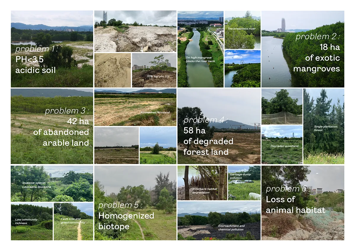
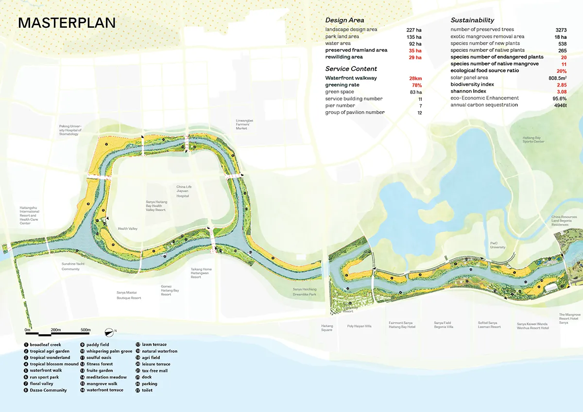
Carved into Sanya’s landscape during Haitang Bay’s urban expansion, Haitang River stands as a 14-kilometer artificial channel linking Hainan’s mountainous interior to the South China Sea. Its creation fueled decades of ecological disruption: natural mudflats (1900s) gave way to industrial aquaculture ponds (2000s), then agricultural runoff zones (2010s), fragmenting wetlands and degrading water quality as development raced forward.
The masterplan confronts this legacy not as a constraint, but as the foundation for regenerative urban design. The river corridor is re-envisioned as an essential green infrastructure, strategically rewiring neglected urban fabric to actively clean water, restore ecosystems, mitigate flooding, and anchor sustainable recreation—demonstrating the adaptive reuse of degraded landscapes for contemporary urban resilience.
A Framework for Integrated Urban Ecology: The Six Steps
Decades of development exacted a heavy ecological toll: agricultural expansion triggered erosion and biodiversity loss, and rapid urbanization fragmented wetlands while concrete channelization severed the river’s natural flow.
The masterplan’s core innovation is the “Six Steps of Ecological Management,” a scalable, science-driven framework translating ecological principles into urban design strategies:
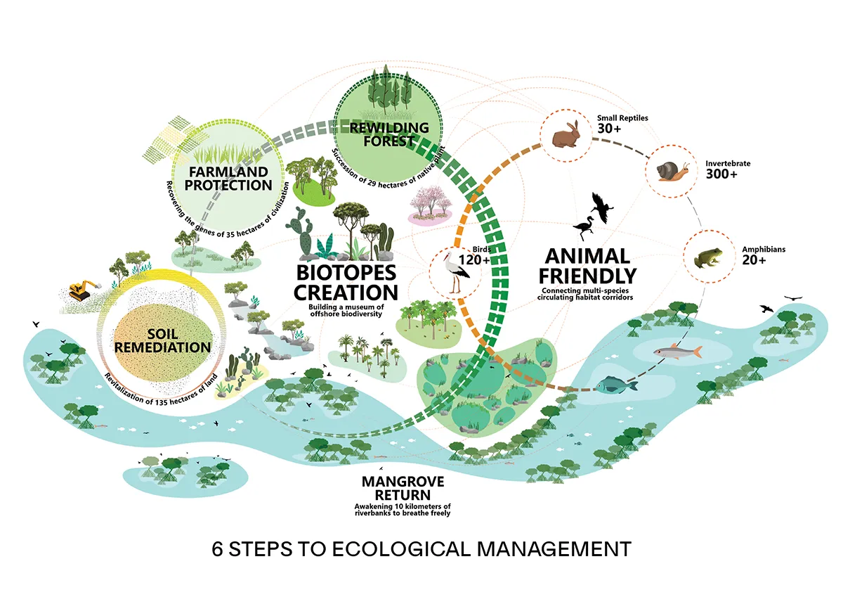
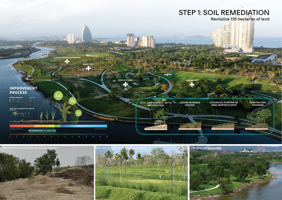
- Soil Remediation as Urban Foundation: Transforming 135 hectares of desertified banks (via topsoil replacement, nitrogen fixation, pH neutralization) created fertile ground for resilient habitats, combating erosion intrinsic to urban fringe development.
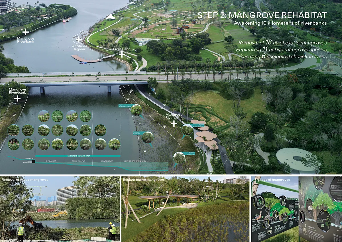
- Mangrove Rehabilitation for Climate Resilience: Replacing 18 hectares of invasive Laguncularia with 11 native species engineered a “breathable corridor,” enhancing flood resilience and water purification – vital flood-resilient urban design for coastal cities.
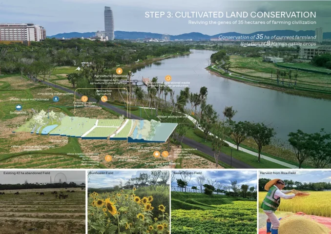
- Farmland Conservation as Cultural Infrastructure: Preserving 35 hectares as productive land art sustains local agriculture and embeds cultural heritage into the public realm, creating vibrant, immersive visitor experiences that support community livelihoods.
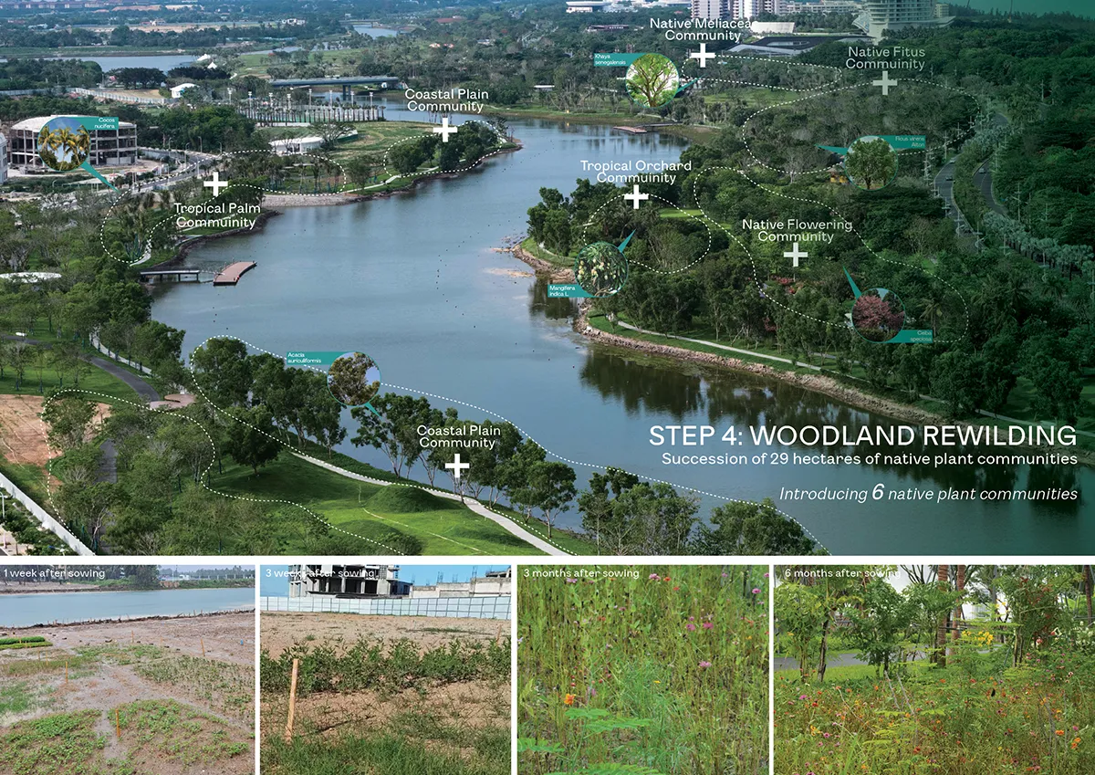
- Woodland Rewilding for Low-Maintenance Urban Greenspace: Twenty-nine hectares dedicated to native plant succession (broadcast seeding) established self-sustaining forests, minimizing long-term maintenance costs while enriching the urban ecological matrix – a model for sustainable park networks.
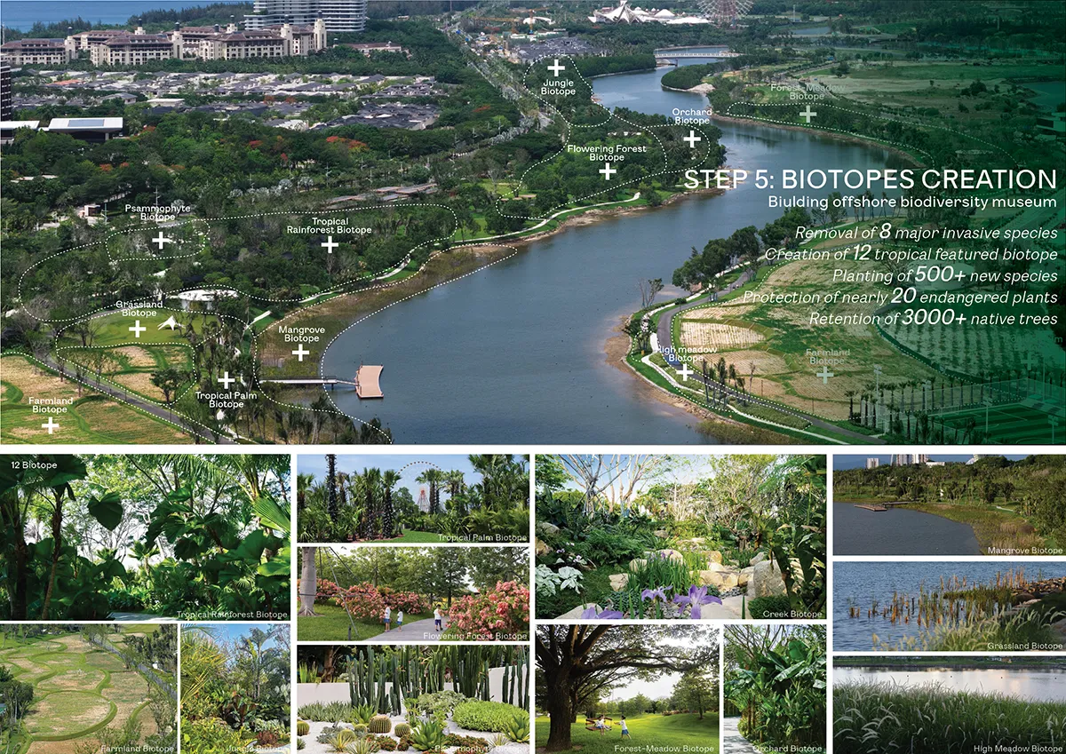
- Biotopes Creation as a Biodiversity Network: Engineering 12 distinct habitats (introducing 500+ natives, removing invasives, preserving 3000+ trees, protecting 20 endangered species) forms an “offshore biodiversity museum,” dramatically boosting ecological function (Shannon Index projected from 0.35 to 3.5). This creates critical biodiversity networks within the urban fabric.
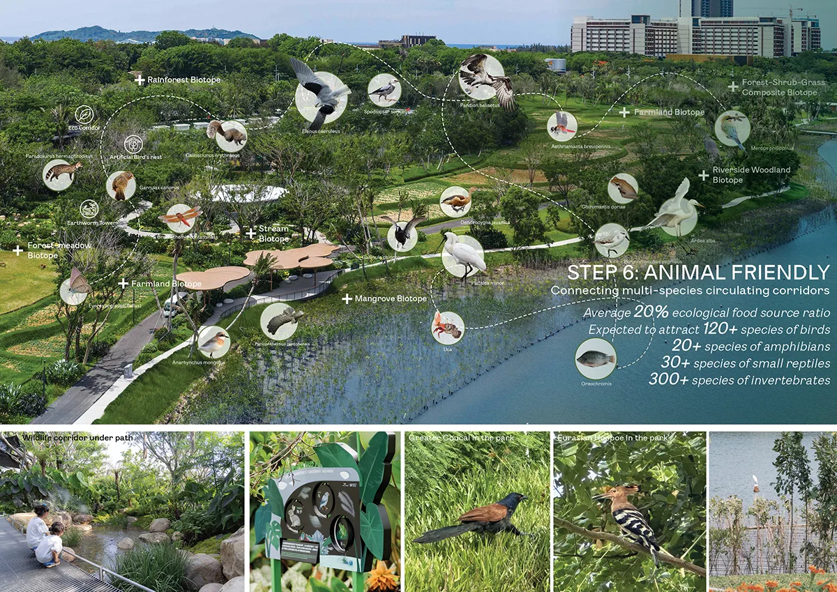
- Multi-Species Corridors for Urban Connectivity: Linking mangroves, farmland, and forests with strategic plantings (20% food species) creates continuous habitat corridors projected to support 400+ species. This ecological belt ensures wildlife mobility, enhancing urban ecosystem services.
Masterplanning for Social Vibrancy and Inclusive Engagement
This linear park transcends ecological function to establish a vibrant public realm for diverse populations. Interactive eco installations embody public health urban design, democratizing biodiversity education. Sensory gardens (tactile roots, aromatic scents, edible plants) and lemongrass-infused wellness trails with therapeutic programming for multigenerational users. Seasonal birdwatching and amphibian walks activate the corridor as a social condenser, fostering neighborhood stewardship.
Critically, 67% tree canopy enables a walkability masterplan—shading pedestrian links between hotels. Repurposed farmland land art sustains local agriculture, embedding productive cultural landscapes within resiliency plans. The masterplan proves green infrastructure plans can drive equitable development: the river corridor now simultaneously functions as flood-resilient urban design (mangroves), economic lifeline (ecotourism), and civic anchor.
A Blueprint for Future Tropical Cities
Haitang River Eco Park masterplan proves that conceptual landscape architecture is fundamental to shaping resilient urban futures. It transforms compromised infrastructure into a thriving civic landmark, fostering Hainan’s eco-cultural identity. The project responds ingeniously to the layered demands of its context, balancing the needs of global tourism with the cultural and social fabric of the local community. It offers a powerful model: urban rivers, reimagined through visionary masterplanning, can simultaneously serve as ecological corridors, cultural links, economic lifelines, and vibrant public spaces for all, demonstrating that development and conservation are not opposing forces but essential, interconnected facets of sustainable urbanism.
Haitang River Eco Park | Sanya, China
Location: Sanya, China
Landscape design: LOLA Landscape Architects Client: China Resources Land Limited
Project Management: Shenzhen Runzhi Urban Construction Management Co., Ltd. Construction Drawings: Guangzhou Pubang Landscape Co., Ltd.
Lighting Design: Handsome Design Consultants (Shenzhen) Co., Ltd. Signage: Shenyang Yibang Qicai Enterprise Marketing Planning Co., Ltd.
Ecological Consultant: Shanghai Zhijie Architectural Design Consulting Co., Ltd. Flower Border Design: Chongqing Tianhua Garden Co., Ltd.
Images and Photo credits: Refer to captions
Shortlisted in the 2025 WLA Awards – Conceptual Masterplanning & Urban Design category