Winner – Award of Excellence in the 2020 WLA Awards for the Concept – Design category
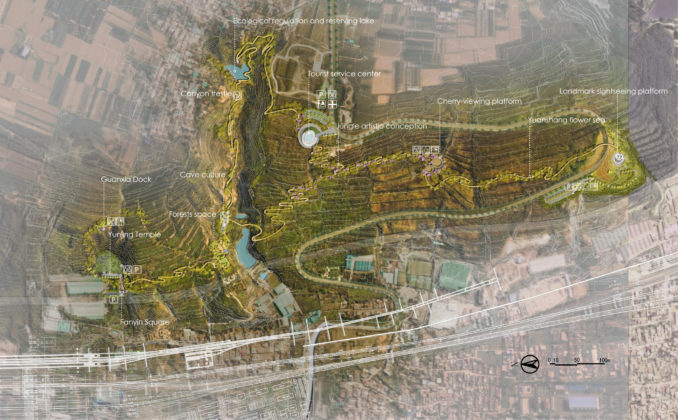
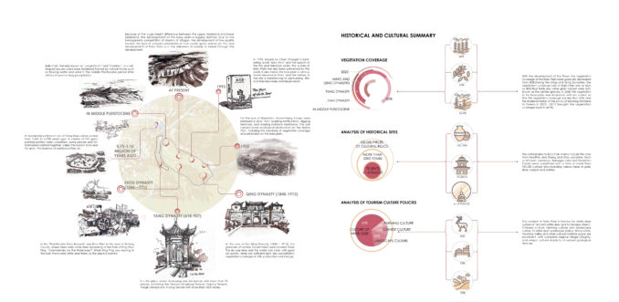
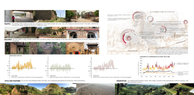
Located in the east part of Xi ‘an city, an ancient city with a history of 3,500 years in China, Bai Lu Yuan(White Deer Plain) is a terrace hit by a river and then covered by aeolian loess, so that it has been formed into a platform loess plateau with serious soil erosion and unique visual landscape. There are many faults in the texture of the west slope of Bai Lu Yuan. A rural road runs through the center of the slope, extending longitudinally from the city under the tableland to the village on the tableland. At the same time, the tableland was deeply cut to form a solid canyon. The branches of the roads connect the different areas of the countryside, and the roads are the only life channels that connect the tableland to the bottom of the tableland. Due to the backward regional economy and inconvenient transportation, the original natural scenery resources, historical and cultural relics and natural villages can be well preserved.
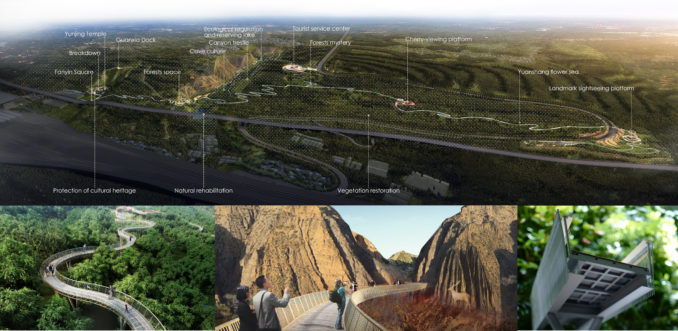
In terms of urban planning, the Bai Lu Yuan area is an important cultural exchange node. The planning starts from data analysis of the natural geography and geomorphology system of the site, and combines the surrounding traffic conditions and the situation of cultural facilities in the meanwhile. It is intended to promote the improvement of soil erosion and the regeneration of ecosystem through the restoration of vegetation system and hydrological system. At the same time, combine the natural landforms and natural villages and other cultural landscape, thus to create a trestle gallery system throughout the whole region. In order to promote the regional function and visual level, shaping the new landscape of tableland plateau, while reshaping the regional vitality, achieve regional regeneration is the final goal.
Major planning strategies
- To improve soil erosion to the greatest extent and firmly maintain the topographic and geomorphic characteristics of tableland;
- Implement ecological restoration to the greatest extent, and improve the state of vegetation, thus to promote the improvement of landscape;
- Create the landmark scene to the greatest extent, and combine the function needs with the traffic improvement, thus to create the corridor frame walking system.
Conservation of water and soil
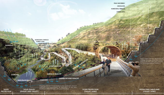
Rain and flood management: prevent soil erosion and reduce runoff through careful site intervention and strong intervention. Strengthen the construction of terraced fields; Tableland protection, slope protection, solid ditch; Leveling the land; Comprehensive treatment of small watershed.
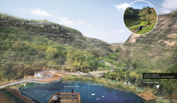
Water system management: the project combines aquatic plants and recreational infrastructure with native water in gullies. It can attract tourists to play in the water body in large quantities, and the utilization and protection of the water body can help to keep a large amount of water in the area. Rain and flood retention pool is also reserved in the landscape to help collecting the water flow in the park and mitigate the impact of increasingly frequent extreme weather disasters on the surrounding residents
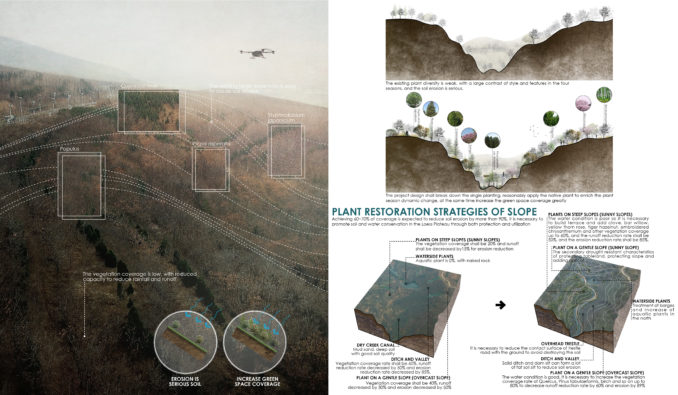
Vegetation restoration: the design of the project breaks the monoculture planting system, while reasonable use of the native plants enriches the plant seasonal dynamic changes, at the same time greatly increases the green space coverage, and realizes the coverage rate to reach 60% ~ 70%, and is expected to reduce the soil erosion more than 90%. The soil and water conservation on the loess plateau can be promoted through protection and utilization.
Mold of the corridor frame of the walking system
Suitability analysis: the base uses UAV aerial photography and geographic data analysis, so it establishes the optimal layout of the corridor and bridge system through GIS analysis data model. Secondly, Ecotect and Phoenics were used to simulate the sunshine and wind environment in extreme weather, so as to determine the wind speed and the comfortable position of sunshine for people to stay.
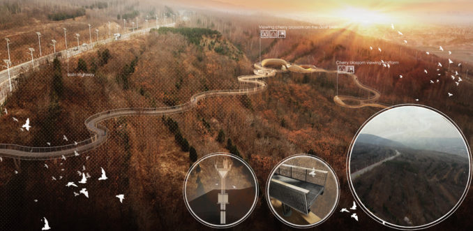
Social value: there are 27 villages in white deer plain, and the transportation system is poor. The establishment of the corridor bridge pedestrian system will link 3 cultural relics of 7 villages within 140 meters of the elevation difference of tablelands, so as to solve the dilemma of inconvenient transportation for local villages.
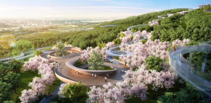
Economic value: the construction of the corridor bridge system will be combined with the One Belt And Road cultural international exchange and development axis. We will connect cultural heritage to enrich tourism nodes, introduce people to develop characteristic cultural tourism. Through making the best use of natural advantages, native culture and historical sites, thus we can create regional upgrading and activate regional vitality.
Environmental Regeneration Planning of the west slope of Xi ‘an Bai Lu Yuan
Location: Xi’an, China
Client: Xi ‘an Chan-Ba Ecological District Management Committee
Landscape Firm: SHUISHI
Design Director – Zhang Songhao
Chief Designer – Hou Yafeng
Design Director – Wang Huiyuan
Designers – Wang Yue, Liu Jia, Li Hongji, Xin Jingfang, Jiang Chunli, Du Ruiwen
Project Principal – Ren Weihu
Plant designer – Wang Wenzhen
Technical Director – Huang Jianjun
Design Director – Deng Gang
Design Director – Sun Chong
Design Director – Shi Li