City New York released the Lower Manhattan Climate Resilience Study, a comprehensive look at current and future climate risks and impacts on Lower Manhattan as a part of the Lower Manhattan Coastal Resiliency (LMCR) project. The study evaluated dozens of adaptation measures and identified a set of strategies to build resilience in Lower Manhattan. The recommendations include developing a plan to extend the Manhattan shoreline into the East River to protect the low-lying and highly constrained Seaport and Financial District area. In addition, the city will advance $500 million for four capital projects to reinforce Lower Manhattan’s coastal areas and provide interim flood protections for the Seaport, parts of the Financial District and Two Bridges neighborhoods, to begin construction between 2019 and 2021.
What is the Lower Manhattan Climate Resilience Study?
The Lower Manhattan Climate Resilience Study builds on past efforts and leadership by the Lower Manhattan communities and the City after Hurricane Sandy, and lays the path forward for the next phase of climate resilience planning towards Lower Manhattan’s future. The study, which was funded by both the City and State through federal post-Sandy disaster appropriations, and led by the Mayor’s Office of Recovery and Resiliency (ORR) and the New York City Economic Development Corporation (NYCEDC) evaluated dozens of adaptation measures and identified a set of strategies to build resilience in Lower Manhattan.
In response to these risks, the City has identified approximately $500 million worth of investments in climate resilience and developed an overall strategy that includes both capital projects and additional planning for increasing the resilience of Lower Manhattan.
Seaport & Financial District – Extending the shoreline into the East River
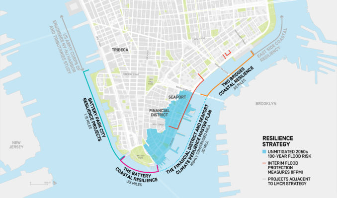
The Study examined a range of options for protecting all of Lower Manhattan, including the Seaport and the Financial District. These areas present unique challenges, including low-lying topography, a lack of available space, dense infrastructure above and below ground, and an active waterfront. The proximity of the FDR, Battery Tunnel and A/C subway tunnels further constrain the sites. Taken together, these elements mean that more traditional on-land flood protection measures are not feasible. Ultimately, the Study found that extending the shoreline into the East River is the only feasible way to protect these vulnerable and vital parts of the city.
The shoreline may be extended by a maximum of 500 feet, or two full city blocks. This will create a new piece of land with high points at or above 20 feet from current sea-level. The new shoreline will act as a flood barrier during storms and protect the neighborhoods against projected sea-level rise. The exact extent of the new shoreline, along with the design and construction of this innovative flood protection system, will be determined through an extensive public engagement process.
Over the next two years, ORR and NYCEDC will complete a Financial District and Seaport Climate Resilience Master Plan, which will include a comprehensive design for the shoreline extension and establish a new public-benefit corporation to finance, construct, and manage it. To begin this process, the City will immediately procure a team of engineers and designers through a Request for Qualification RFQ later this month. The Master Planning Process will be complete in 2021 and will identify a first phase project.
Protecting Against Future Risks
In response to these risks, the City is advancing approximately $500 million worth of investments in climate resilience as part of an overall strategy that includes both capital projects and additional planning for increasing the resilience of Lower Manhattan.
The City is making targeted, ambitious investments that will deliver significant climate adaptation measures for key neighborhoods of Lower Manhattan:
In the South Street Seaport area, parts of the Financial District and Two Bridges neighborhoods, Emergency Management (EM) will spend $3.5 million to deploy a combination of just-in-time Tiger Dams and pre-deployed HESCO barriers by the 2019 hurricane season as temporary measures in advance of a permanent solution.
In Battery Park City, the Battery Park City Authority (BPCA), with $134 million in bonds, will reconstruct its esplanade and open space to adapt to new climate conditions. BPCA kicked off

In The Battery, NYCEDC, in partnership with NYC Parks, BPCA and the Battery Conservancy, will invest $165 million to elevate the wharf and esplanade and integrate a protective barrier such as a berm at the back of the park. This design will preserve the look and feel of the existing park while strengthening the shoreline. Construction will begin in 2021.
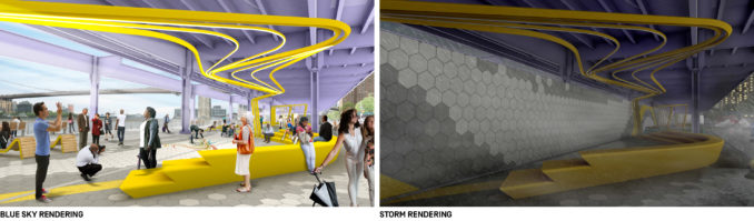
In the Two Bridges neighborhood, NYCEDC is designing an integrated flood protection system comprised of permanent barriers and deployable or ‘flip up’ protections that will protect view corridors and public access. DDC will manage construction of the $200 million investment, which will begin in 2021.
Community Engagement
Beginning in the Spring, the City will establish a robust community engagement process to discuss the study, its strategies, dedicated investments, and further planning. Dedicated community outreach programs will take place for each of the advancing capital projects as well as for the Financial District and Seaport Climate Resilience Master Plan. Community engagement for the Master Planning Process will inform the extent of the shoreline extension and topside programming and identify a first phase project.
Updated Climate Resiliency Design Guidelines
As part of ongoing citywide efforts to increase the resiliency of City buildings and infrastructure to the impacts of climate change, the City also released the third version of its Climate Resiliency Design Guidelines. Since New York City facilities built today will remain in use for many decades to come, it’s critically important that they be designed to withstand the long-term impacts of climate change based on the best available science.
These publicly available guidelines, which are recommended for use in municipal capital projects, equip engineers, architects, and planners with the tools and information they need to integrate future climate data into their designs. These guidelines were developed using local climate change projections that have been collected and refined over 10 years by the New York City Panel on Climate Change (NPCC). Using the Guidelines helps protect the built environment and the services New Yorkers rely
Read more at
https://www.nycedc.com/project/lower-manhattan-coastal-resiliency
Download the Lower Manhattan Climate Resilience Study [pdf] at
https://www.nycedc.com/sites/default/files/filemanager/Projects/LMCR/Final_Image/Lower_Manhattan_Climate_Resilience_March_2019.pdf
Download the third edition of the Climate Design Resiliency Guidelines
[pdf] at https://www1.nyc.gov/assets/orr/pdf/NYC_Climate_Resiliency_Design_Guidelines_v3-0.pdf
SOURCES: City of New York; Battery Park City Authority; NYCEDC;