one canal, two landscapes, many layers
conflicting demands
Parklands in the contemporary city are facing a series of seemingly conflicting demands.
They need to provide: balance to, and escape from, the cultural activity of the city; cultural amenities essential for people to come together for rest and recreation; a healthy ecological system for indigenous flora and fauna; and, space for rural food production.
Unfortunately, the orthodox, often picturesque, and mostly isolated urban park struggles to reconcile these seemingly conflicting demands.
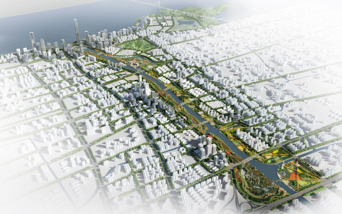
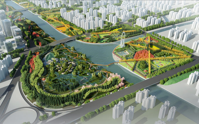
one canal
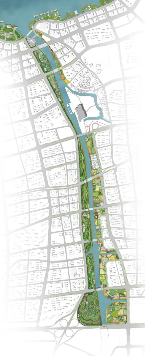
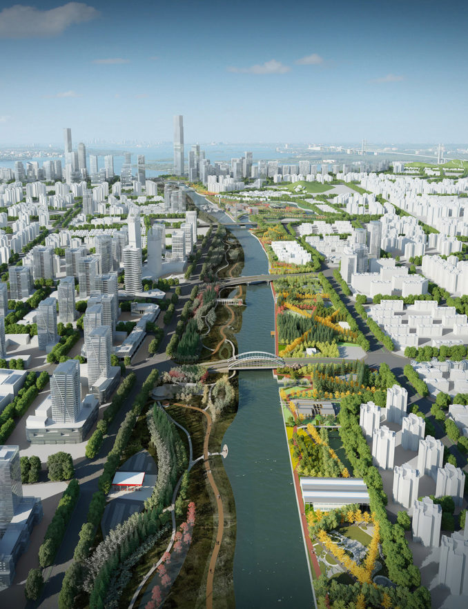
The Yangtze River momentarily narrows to one kilometre at Jiangyin, allowing a suspension bridge to be built. The bridge is the first crossing of the river upstream from Shanghai and has enabled Jiangyin’s rapid growth. Xicheng Canal is an ancient canal linked to the Yangtze River and forming an integral part of central China’s water transport network. It forms one length of Jiangyin’s planned park network. The city’s 23 kilometre greenway cycling path passes through the canal landscape.
two parks
BAU see the conflicting needs for both natural parkland and cultural parkland as an opportunity to provide two parks, one either side of the river – on the west bank, a continuous ecological-indigenous landscape; on the east bank, a continuous cultural landscape.
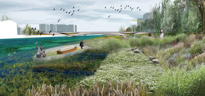
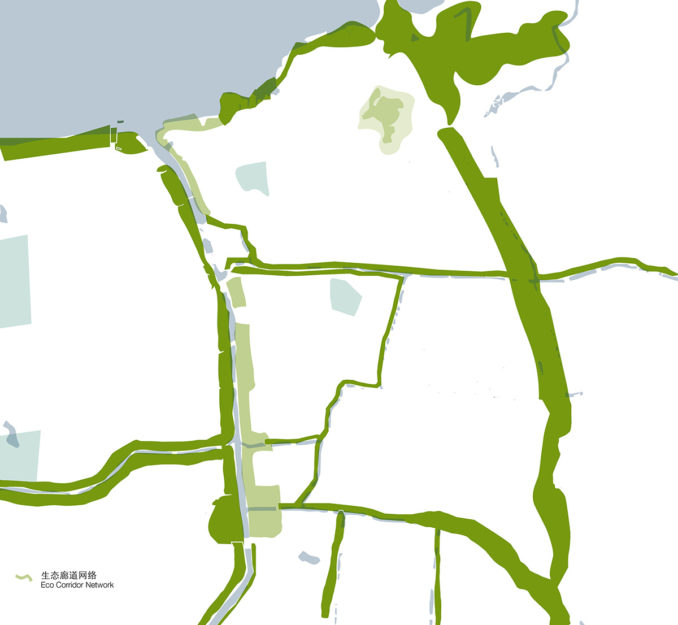
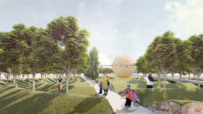
eco-park
The development of indigenous eco-system corridors is far from common practice in contemporary Chinese landscape and city building, particularly outside of the major cities. Nevertheless the client has agreed to pursue this concept for the west bank eco-park.
The unique ecological functions of riparian zones are linked to dynamic biophysical processes and interactions across multiple spatial and temporal scales. Maintaining these interactions, and the connectivity driving them is a fundamental requirement for maintaining healthy riparian zones and the many functions they provide. Effective maintenance requires connectivity, both in the timing and extent of flows, as well as in the movements and types of animals.
Nutrients from terrestrial vegetation (e.g. plant litter and insect droppings) are transferred to the aquatic food webs. The vegetation also contributes wood debris to streams, which is important to maintaining geomorphology. The assortment of riparian zone vegetation differs from those of wetlands and typically consists of plants that are either emergent aquatic plants, or herbs, trees, and shrubs that thrive in proximity to water.
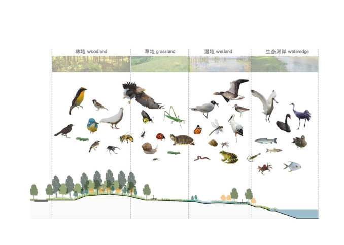
Strategies to facilitate this eco-park concept include: four kilometers of existing flood walls along the canal will be replaced with soft edges to develop the aquatic ecosystem and to give fauna access to a permanent water supply; raised boardwalks and tunnels beneath necessary on-ground paths further enable fauna movements; and 10 insect “hotels” located along the four kilometer eco indigenous park to stimulate insect life.
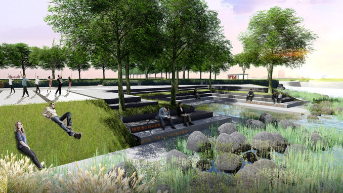
These initiatives will encourage a healthy riparian eco-system, provide a bio filter to enhance water quality; provide food and shelter for aquatic and land animals; enable migration of fauna along the river system avoiding isolated communities; and finally to recover and develop fish populations.
Connections to a network of other eco-indigenous corridors within and beyond the city limits is the broader ecological strategy.
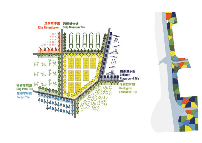
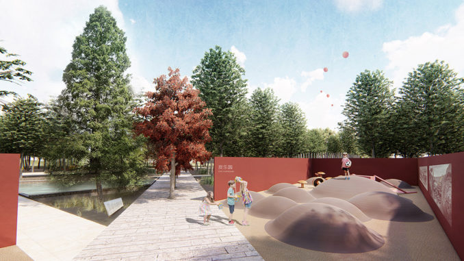
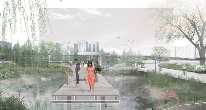
culture-park
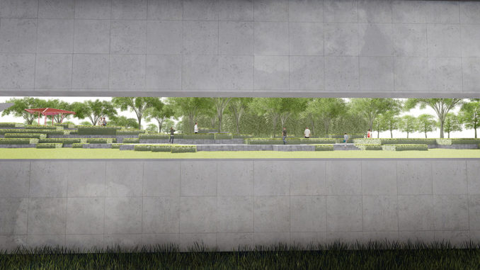
Seen as a complex, rich and rewarding cultural surface, the east side of the river embraces the cultural aspects of parks and gardens including, past and present programs, and the ability to easily accommodate changes in the future.
The site is divided into a tessellated tiles, a gesture that provides both circulation and access to many large parcels of open space. The paths become a continuous irregular ecological network within the cultural park and provide excellent permeability. The independent tiles are free to be both different and to be able to change without compromising any of the others.
many layers
BAU identified each design issue involved in this project and developed an independent ideal, uncompromised or utopian solution for each of those issue. These ideal layers have been put together in a rich and complex assemblage. Any conflict within the assemblage was solved locally while maintaining the layer(s).
A number of other urban issues were identified and a layer developed for each. These issues include:
palimpsest
This cultural park makes visible parts of what has been removed and uses those fragments to advantage. Thresholds of historical precincts are redefined, walls lost to demolition are partially rebuilt to frame views, or become seats and benches, increasing amenity for the park users.
peripheral paths
Both the eco-indigenous and the cultural park have a peripheral path that runs between and under existing vehicular bridges, providing highly accessible edges to both parks.
desire lines
From every intersecting street, a path leads directly to the river. In the wider park areas, shortcuts are provided so pedestrians can cut diagonally through the park to the next intersecting bridge. In addition, the eco-park has a path running through the centre, a quiet route through nature.
existing buildings
Existing buildings are recycled and re-programmed to become part of a post-industrial landscape – either on green islands within the new eco-park, or becoming the focus of new cultural programs and activities in the cultural park.
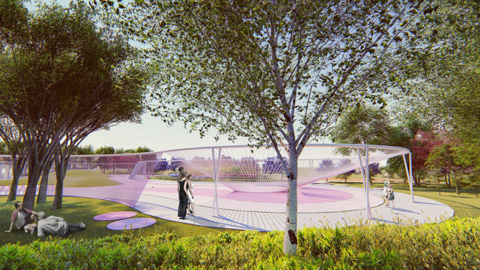
pavilions
Both parks have programmed pavilions distributed fairly and evenly throughout. From extra-small programs (picnic, mahjong) pavilions at 2.5 minute intervals; to small programs (children’s playground, kiosk) at 5 minute intervals; to medium programs (table tennis, cafe) at 10 minute intervals.
uncompromised
This project provides a new uncompromised landscape despite the conflicting landscape demands of this new century.
Designer: BAU Brearley Architects + Urbanists
Project Status: Invited competition, 1st prize. Stage 1 under construction.
Location: Jiangyin, Jiangsu Province, China
Year: 2017 – ongoing
Client: Jiangyin Planning Bureau
Construction Area: 151.6 ha( including waterbody area 40.9 ha)
Typology: Public landscape
BAU Project Team:
Directors: James Brearley, Steven Whitford, Fang Qun.
Landscape architecture: Huang Fang , Guo Liexia, Gu Zhuocheng(Jackie), Zhang Yi, Pan Linlu(Berry), Shi Zhengting, Zhang Xinwei, Pan Guo, Wang Chenlei, Luo Li , Xiong Juan, Alex,Tan Min,Ni Yang, Cheng Qi,Yuan Yao,Chen Yanling,Chen Xingyuan,He Yuqing (Mona),Lei Tao,Zhu Li. Wu Xiaojian(Sharon)
Architecture: Jiang Han, Milly Gamlin, Hu Wenjun, Li Zhen, Chen Zhiyong, Wu Zhiying, Wang Juan, Lin Shengzhe, Xu Shenghang, Jiang Yujia, Jiang Han, Zhang Dejun, Prague Unger, Wang Xiaoqi, Li Xiao, Chen Zhiyong, Lu Penghong. Jens Eberhardt.
3D team: Weng Jiabiao, Niu Yingying, Lv Xinping,Wang Xiaodan, Huo Guanqiang, Sun Libao, Xia Mengjia, Cao Yingchen, Chen Xin.
Image credits: BAU