Anyone who is familiar with BIM and BIM software has almost undoubtedly heard of Revit. Revit is a fairly popular BIM platform, particularly among architects and building engineers. It is less commonly used by landscape architects, and is frequently declared as “unsuitable” for landscape modeling. Yet the reasons behind this verdict are often left unexplained, which is not helpful for those who would like to understand more about Revit and the BIM process.
So in an effort to share more specific and useful information pertaining to BIM and landscape architecture, here are some of the biggest issues and challenges that I have discovered while using Revit, both generally and as a landscape architect.
Like any software, Revit does have some drawbacks that might make it less appealing for some users. From the outset, Revit has two immediate challenges that affect all disciplines (including architects, engineers, and landscape architects): greater software cost and longer implementation time. These two “issues” are prevalent in almost any BIM software, but might be slightly more acute with Revit.
Starting with the cost, a single Revit license is $2,000 per year. For comparison, AutoCAD is only $1,680 annually, but Revit is a bit different in that it is generally required to stay up-to-date with the latest version every year, while with AutoCAD you can easily get by without the latest version. However, with Autodesk moving all of its products over to subscription only, this might make the cost difference almost negligible.
The second issue of longer implementation can be separated into two parts: it has a steeper learning curve and also requires substantial time to build a content library. Again, this is an issue that affects all disciplines within Revit, however with the added difficulties of applying Revit to landscape architecture, the learning curve can seem even steeper than average.
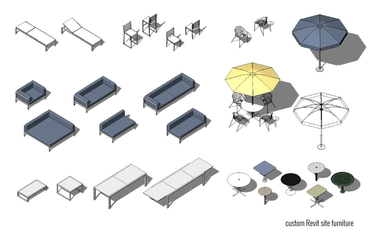
There is often a misconception that one of the barriers within landscape architecture is the lack of landscape Revit content available. While it is true there is not much landscape content, it is worth noting that Autodesk has historically provided very limited architectural and engineering Revit content. And in fact, the firms that currently use Revit most effectively have created their own content libraries over time. So what is perhaps most needed is simply the sharing of knowledge so that more landscape architects can learn how to create their own content.
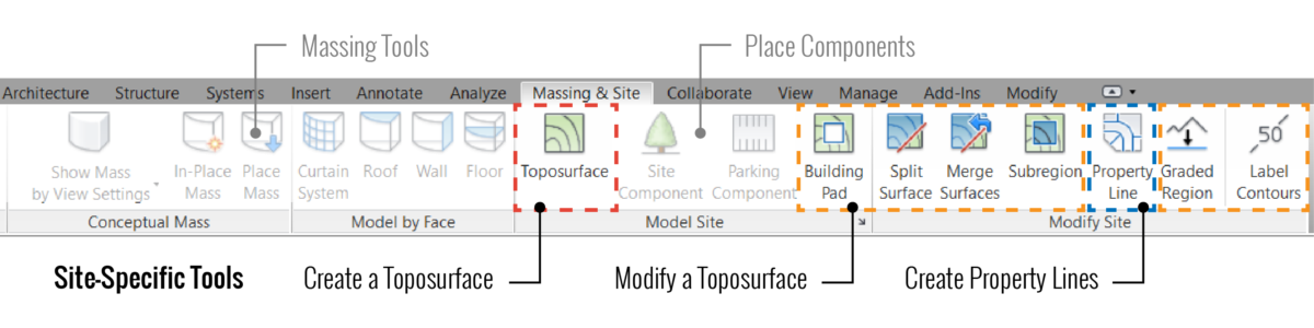
Within the realm of landscape architecture, the main issue with using Revit is the lack of landscape-oriented workflows. This can be seen immediately on the ‘Massing and Site’ ribbon in Revit, where there are essentially only three site-specific/landscape tools: Create a Toposurface, Modify a Toposurface, and Create Property Lines. Of these three tools, the first is easily the most substantial in regards to modeling.
Topography is usually the base for creating any site or landscape in Revit, but currently it is both time-consuming and difficult to modify. These two issues stem from an overall problem with the surface engine; its only input is points and it does not allow you to adjust the output (the triangulation and contour lines). This causes some obvious problems when trying to fine-tune a surface to match certain contours or even simply match a TINN surface.
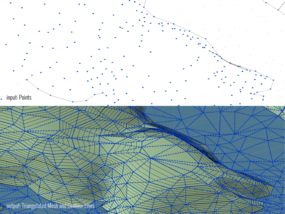
The properties of Topography are also unfortunately limited. There is no way to smooth the top of the surface, which is represented as a triangular mesh. There is also no way to delineate multiple soil types and depths; it is limited to a single material with an infinite depth. And within that single material, there is no way to create a tunnel or underground space below the top of the surface. Also, Phasing from existing conditions to proposed changes must be combined into a single Toposurface, which can make it even more difficult to manage those changes.
In addition to dealing with imprecise and difficult Topography, Revit does not have any built-in tools for modeling water or hardscape elements (such as roads, sidewalks, curbs, or any other pavement). Though there are other elements, such as Floors and In-Place Components, that can be used to model hardscape and curbs, these workarounds have their own issues, such as not interacting with Topo and displaying hardscape patterns incorrectly. And with such a significant lack of landscape-oriented workflows, it is hardly surprising that there are also no built-in tools for grading (or applying multiple slopes).
Another issue related to Topography and hardscape, is that Parking Components cannot interact correctly with a multi-sloped surface. This results in Parking lines that are frequently embedded into or even floating above a surface.
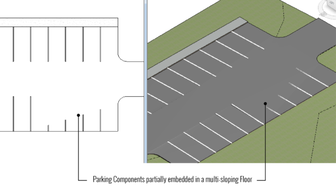
There is also no way to keep Parking in a bay or an array and also host to a varyingly sloped surface. These two these issues result in Parking Components that are both difficult to manage and inaccurately represented within the model.
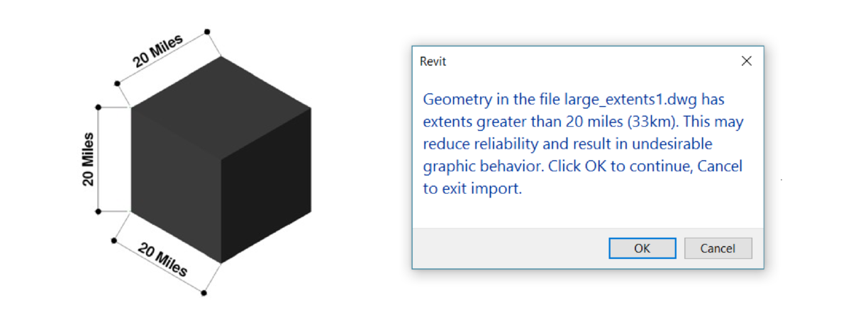
Outside of its internal site tools, Revit also lacks the capacity to support many civil and infrastructure workflows. For starters, Revit file extents prefer to be kept within 20 miles in all directions (essentially a 20 mile cube). This limitation will result in warnings when working with larger dwgs, which unfortunately can happen quite frequently. And on larger landscape and civil projects, this arbitrary extents also has the potential to cause issues in the model.
Furthermore, Autodesk also offers almost no interoperability between Revit and Civil 3D. This is an issue that they appear to be trying to fix, but the current workflows between the programs are shockingly limited. As it exists today, a Revit user can link a Civil 3D dwg file, but this link does not transfer any information from AutoCAD to Revit. In the other direction, an AutoCAD user can xref a Revit file that has been exported to a dwg file. But again, this does not transfer any information from the model and a dwg export is not a live link, which further limits the entire workflow.
With all of these issues, Revit is certainly not a perfect landscape BIM solution. And after reading this article some might wonder why any landscape architect would even consider using it. But while Revit does have many shortcomings in regards to sites and landscapes, it also has many features that can improve modeling workflows, automate documentation, and enable better coordination. Stay tuned for the last part in the series, which discusses the benefits of using Revit to model landscapes.
Lauren Schmidt is a graduate landscape architect and the author of landarchBIM, a blog that focuses on BIM and design computation in landscape architecture. She is an avid Revit user and has also created an online video training course, Revit Landscape: An Introduction to Revit and Site Modeling.
Lauren Schmidt and the author of landarchBIM is a World Landscape Architecture Partner