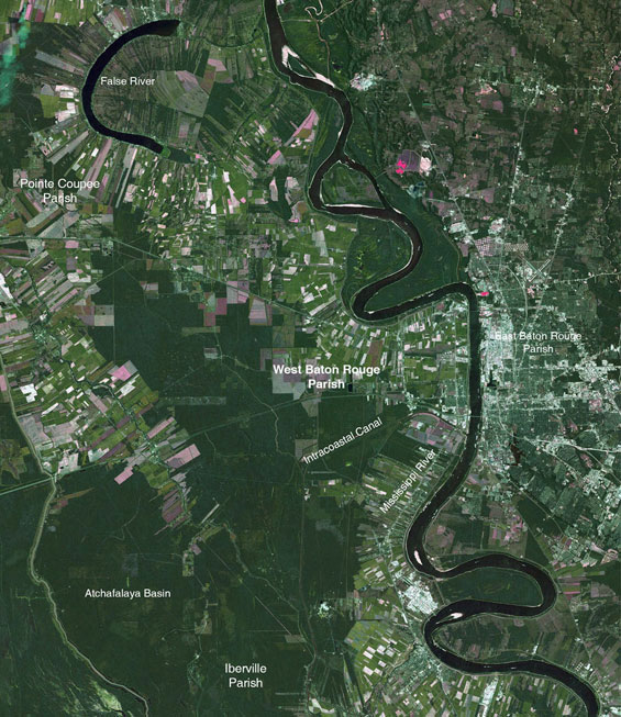
West Baton Rouge Parish has a total land area of 122,000 acres with a population of only 22,000 residents but has exceptional assets: a rich agricultural heritage and abundant natural resources within close proximity to a major metropolitan region. Plan West, the West Baton Rouge Parish Comprehensive Master Plan was created to preserve the unique qualities of the Parish while providing a framework to guide future growth for the next twenty years.
Project Narrative:
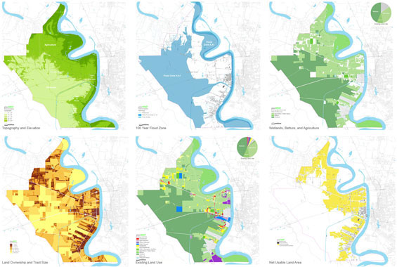
While agriculture, wetlands, and forest remain the predominant land use, new patterns of growth, development, mobility, and regional economic changes have begun to affect traditional land use patterns within the Parish. Recent trends such as the” leap frog development” of residential subdivisions into agricultural areas and strip development along corridors threaten the long term viability of current agricultural land uses while increasingly straining the resiliency of the Parish’s natural resources. Plan West includes a number of model agricultural and resources conservation programs that are designed to equitably preserve the Parish’s natural resources and create an environment that supports the business of agriculture within a changing landscape. Twenty year population projections will result in an additional 2000 to 6000 new households (at 1% and 3% growth models), Plan West is a strategy to guide future growth in and around existing communities to create compact, inclusive, mixed-use, and walkable, villages and neighborhoods; that capitalize on existing investments in infrastructure while preserving large contiguous tracts of the rural landscape.
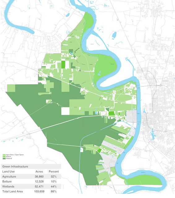
Green Infrastructure: Natural and Agricultural Systems
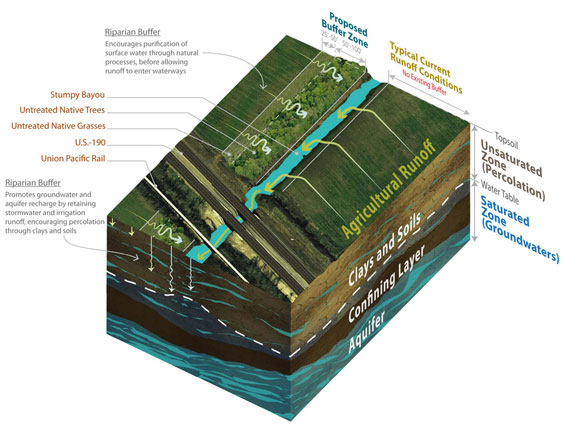
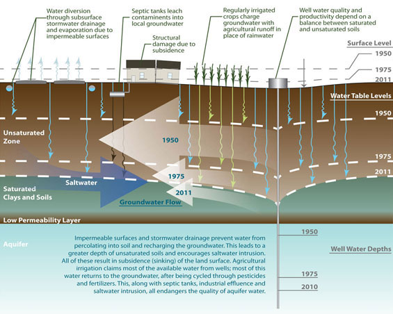
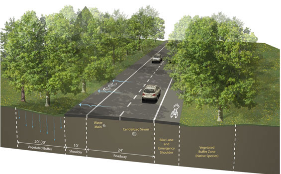
Despite recent trends of rural sprawl and strip corridor development West Baton Rouge Parish’s large contiguous tract of wetlands, forest and agriculture are still mainly intact. While two thirds of the Parish’s land is used for agriculture or related rural land uses there are currently no agricultural preservation or natural resource conservation programs in place. Maintaining and perpetuating the long term viability of farming will be a challenge in the face of future growth. Scattered residential development, the national trend of a declining agriculture industry, and the subdivision of large tracts of lands as they are passed from generations, all threaten the long-term viability of agriculture, and the Parish’s natural resources. Plan West is a green infrastructure approach to managing the Parish’s agricultural lands, open space and natural resources as single interrelated system. The adoption of a Local Right to Farm Ordinance, Agricultural District Programs, Agriculture Protection Zoning, a Purchase of Agricultural Conservation Easements Programs, and Agricultural Buffers are designed to protect the long-term viability of current and future agricultural practices. Conservation Easements, the development of a land banking system, and a Purchase of Development Rights Programs encourage private land owners to preserve natural resources while providing economic equity. Water quality issues are addressed through a riparian buffer program, zero impact ordinances, a policy of preserving flood plains as open space, and agricultural nutrient management programs.
Land Use, Housing, and Neighborhoods
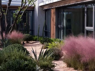
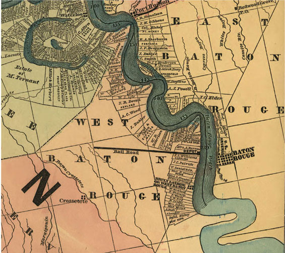
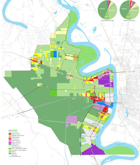
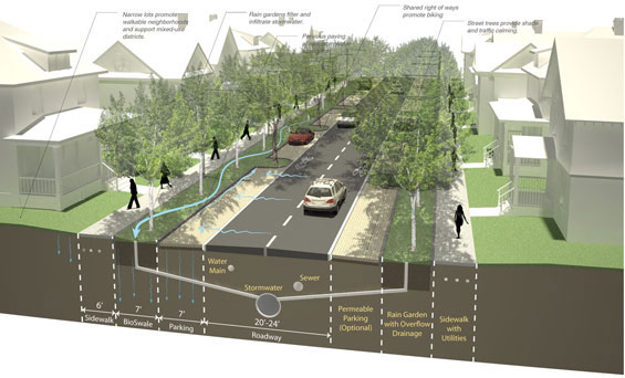
Current land use patterns and trends in West Baton Rouge Parish reflect the Parish’s rich agricultural history, early cadastral patterns and recent influences such as the growth of the petrochemical industry, expansion of the Port of Baton Rouge and warehousing industry, and the development of suburban neighborhoods. The Parish’s historical development is closely tied to its location along the Mississippi River where early settlements were developed near the river’s natural levee, on the highest ground. Informed by historical development patterns Plan West is a strategy to guide future growth into and around existing communities in areas free of environmental constraints. Future development will occur in compact, walkable, mixed-use village and neighborhood centers that provide a range of housing choices, ample open space and parks, expanded retail and services for residents, and opportunities for social interaction. The Future Land Use Plan, policies, and strategies provide a framework that promotes infill development and sustainable land use patterns.
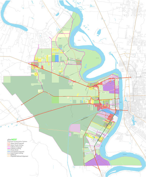
Transportation and Mobility
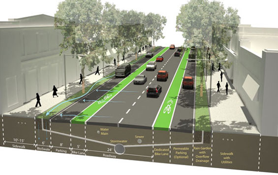
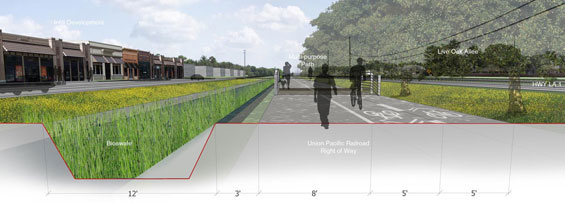
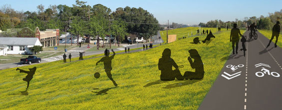
As with the majority of rural Louisiana motor vehicle travel is the only viable mode of transportation. As a result development activity and intensity is directly influenced by its proximity to major transportation corridors. The Future Connectivity Map and Future Land Use Map were developed in conjunction to ensure seamless integration of transportation networks with compatible land uses and facilitate the preservation of natural resources. Taking a context sensitive approach Plan West illustrates the greening of highway corridors, interconnected streets and sustainable approaches to water management. The Bike and Trails Plan is designed to connect existing and future neighborhoods to schools, parks and commercial centers, and includes a continuous 21 mile long multipurpose levee path that connects to the Mississippi River Trail. A re-purposed freight railroad right of way is converted to a multipurpose path and form a key component of the regional trail system.
Economic Development
Increasingly places must compete to attract and retain businesses and residents. The long term economic growth of the Parish is dependent on creating a sustainable environment that is attractive to both employers and residents. A priority of Plan West is to improve the Parish’s air quality and remove EPA non-attainment designation. This will be achieved through the development of partnerships with industry and compact developments that mix land uses and minimize commutes. Other quality of life initiatives include the development of high quality inclusive mixed use villages and neighborhoods, the development of regional serving retail and a parish wide park and trails system are designed to create an environment that is attractive to residents and businesses. The plan also includes initiatives that supports the rural landscape; sustainable, organic, and buy local agricultural programs capitalize on the Parish’s large agricultural base and provide a local food supply to the larger regional population.
Public Facilities, Services, and Infrastructure
Issues related to land use, storm water management; public services; utilities and transportation are regional and local problems that can only be addressed through cooperation between regional agencies; the Parish administration and smaller municipalities. Plan West includes a number of policies to facilitate intergovernmental cooperation. Infrastructure policies include the development of regional sewer and water service, and an adequate facilities ordinance to encourage development within areas served by existing infrastructure. Water conservation measures include zero impact ordinances, a policy of minimizing impacts to natural resources and sustainable policies encouraging water infiltration and aquifer recharge. As a component of the Parish green infrastructure network the future parks plan includes the development of a regional parks and smaller neighborhood parks that provide opportunities for recreation while also providing sustainable approaches to water management and wildlife habitat.
Process and Implementation
Plan West was developed in five phases through a transparent and open public dialogue. At the beginning of the planning process a steering committee was formed to ensure a transparent planning process, and oversee implementation efforts. The implementation plan is guided through 76 action items outlining the responsible governmental agency, timeframe and budget.
Plan West: West Baton Rouge Parish Comprehensive Plan
Lead Design Firm: Tipton Associates
Lead Designer: Scott D’Agostino
Project Location: West Baton Rouge Parish, Louisiana, USA
Consultants: Sasaki Associates; Planning and Urban Design
PESI, Inc.; Civil Engineering