The goal of this project is to propose a replicable and site specified progressive rehabilitation design in order to enhance the integrity of the existing ecosystem of the ORM. Instead of dismissing the features created during the extraction process, these features will be used as landscape design tools to celebrate the hidden power of them.
Site Context:
The Oak Ridges Moraine is a 160-kilometre-long landform that contains the highest diversity of wildlife in the GTA. An east-west trail was provided in order to allow the general public the chance of experiencing and enjoying the unique environment of the ORM.
The other feature that makes the moraine significant is its unique geological land formation, which makes it a great source of sand and gravel. With the increase of population and urbanization, the demand for aggregate extraction increases in our world. On the other hand, the need to preserve the natural assets also increases as urbanization develops. In response, the numerous sand and gravel pits will be extracted, cleared and rehabilitated, resulting in the ORM being comprised of different patches of golf courses, parklands and vine gardens.
Site:
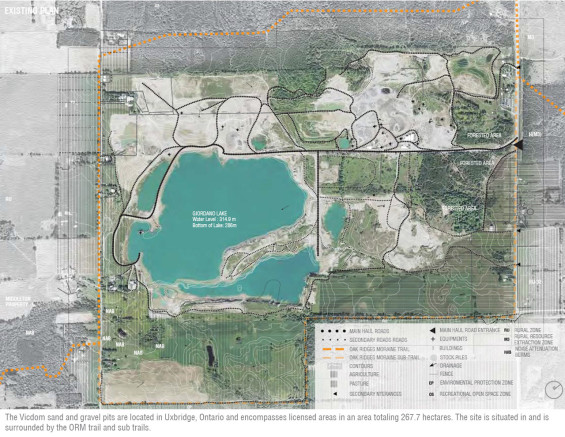
The Vicdom sand and gravel pit located in Uxbridge Township (the trail capital of Canada) in the Oak Ridges Moraine is one of its numerous kinds of pits reflecting the contrast between manmade extraction holes and the natural heritage of the area. The main ORM trail passes close to the north boundary of the site and the sub trail passes exactly to the south.
Strategy:
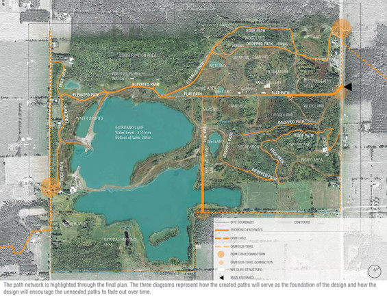
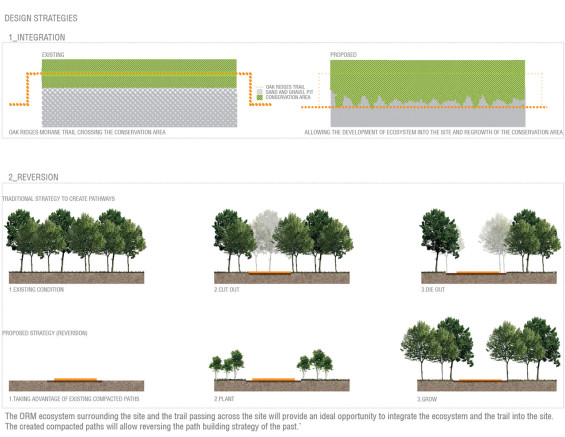
In order to encourage the growth of the ORM ecosystem, connect the site to its surrounding environment and involve the public throughout the progressive rehabilitation design, the proximity of the ORM trail to the site has been taken into account.
In order to incorporate the ORM trail into the site, a detour from the original trail will enter the site on one side and rejoined with the original trail on the other side. This will also allow the conservation area that the existing trail passes through, a time to rest and rejuvenate.
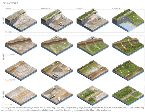
Tool Kit:
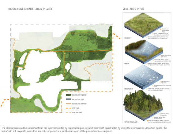
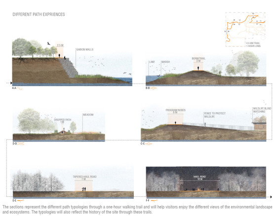
The typical strategy for trail construction usually results in the cutting of trees and the destruction of existing vegetation to create new paths. Additionally, the plant life close to the constructed paths will die out due to the expansion of soil compaction. This project proposal will reverse the process. It will utilize the power of the existing paths created during the excavation process to set the foundation for future phases of the project. These paths will be used as a boundary for designating where wildlife habitation, vegetation and human interaction areas will be. The trail will be diverted gradually through the progressive rehabilitation phases and expressed through 4 path typologies being edge, elevated, dropped and tapered. They will be developed based on site condition, rehabilitation phasing, proximity to the haul roads and excavation processing areas.
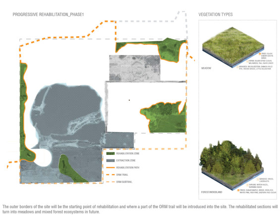
Extraction _Phase1:
In phase 1, the excavation process is in its early phases and no areas have been cleared, therefore the edges of the site will be taken into account and will be the starting point of rehabilitation and the introduction of the ORM trail into the site.
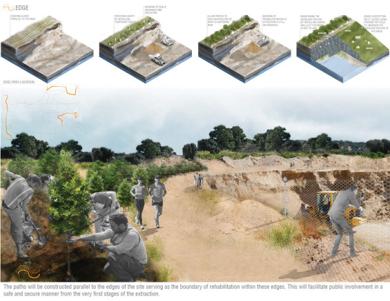
Path _ Edge:
Initially paths will be constructed parallel to the edges of the site. The edge condition will allow integrating the public into the site safely and allow them to have an overview of what is currently happening and imagine what could happen in future. This is the beginning of public awareness and education about this project.
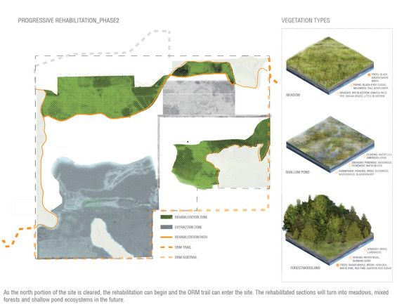
Extraction _Phase2:
As the north portion is cleared the ORM trail can enter the site and rehabilitation can begin.
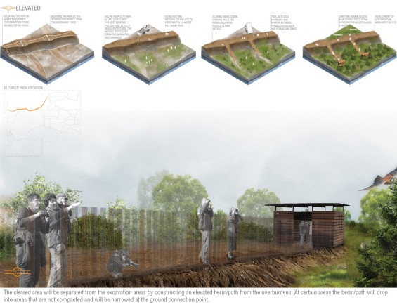
Path _Elevated:
The cleared area will be separated from the excavation areas by constructing a 2.5-meter tall berm path over the existing compacted paths made from the overburdens.
This Berm/Trail will allow people to observe the current activity on the site while separating and protecting the wildlife area from the noise, dust and pollution created at the other side of the site. This will hopefully encourage the natural wildlife to proliferate in the designated area and reflect the history of the site in the future. At various points along the trail there will be designated program nodes which sit on the current intersection points of the trail and existing secondary paths.
At the node points there will be some smaller sloping trails down toward wildlife areas based on the secondary paths locations. These paths will be phased out over time by the development of the vegetation into the area and will be blocked by wild life blinds to be used for observation only.
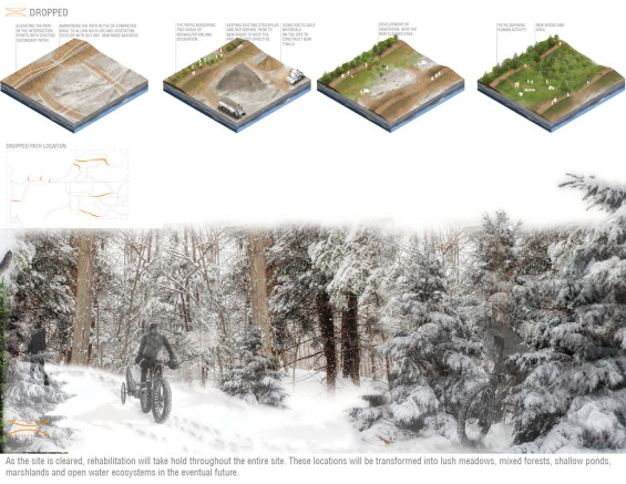
Path _ Dropped:
At certain points the berm/trail drops into areas that are not compacted and will be narrowed at the ground connection point. This will allow wildlife and vegetation on the other side to develop without any man made interference.
Extraction _Phase3:
The excavation has been completed and the rest of the site is ready to be fully rehabilitated.
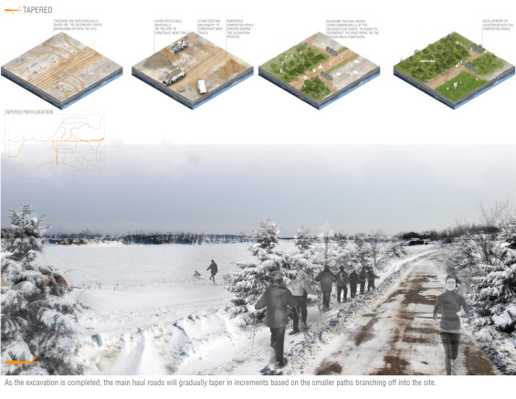
Path _Tapered:
As the excavation has finished, there is no need for a wide haul road of 18 meters in width, so by decreasing the compacted path widths, the main haul roads will gradually taper in increments based on the smaller paths branching off into the site.
The process of de-compacting these paths will start by blocking them with gabion walls in the branching points of the secondary paths in order to allow these paths to taper gradually by the development and growth of vegetation.
There are numerous sites close to the ORM trail, which have the same characteristics due to the nature of sand and gravel excavation. Therefore the template of this design can be the principle by which the other excavation sites can be rehabilitated. This design proposal will enhance Oak Ridges Moraine’s integrity, protect the ecosystem, and will allow visitors to experience and appreciate the various states of this transformation.
The Power of Paths
Site: Vicdom sand and gravel-
Site Location | Lots 10 -11-12-13 AND 14 -Concession 4
Township of Uxbridge, Regional Municipality of Durham, Ontario, Canada
Designers | Afshin Ashari & Ameneh Kadivar
Status | Candidate for master of landscape architecture
University of Toronto